


The urban development of the city of Alicante expanded into a coastal area that, in ancient times, was a natural floodplain or marsh. However, despite the construction of a large rainwater drainage network, flooding persisted during heavy rainfall episodes.
To solve this problem, the construction of a large underground storage tank was planned within a municipal plot designated for a green area, with a capacity of 45,000 m³, which was estimated to be sufficient to temporarily store the surplus water from a rainfall event with a 50-year return period.
The uniqueness of this nature-based solution lies in the use of an urban public park that is designed to occasionally serve as a temporary rainwater retention tank. This approach reduces environmental impact by avoiding direct discharge into the sea, provides notable social benefits by creating a new green area, and enables the purification and reuse of the stored water.
Since the 1960s, various works have been carried out to improve drainage capacity in the city of Alicante, which is cyclically subjected to episodes of moderate or heavy rain, causing serious flooding in some low-lying areas of the city, such as Playa de San Juan, while also losing the opportunity to reuse this natural resource. To this end, the city had three large drainage channels that directed rainwater straight to the beach.
However, during episodes of intense rainfall, the capacity of these channels was insufficient, and flooding systematically occurred. It is also necessary to consider that climate change is affecting the intensity and frequency of certain extreme weather events.
Faced with this recurring situation and its potential worsening in the future, the City Council and the public company Aguas de Alicante initiated the study of a long-term solution for the area, with the aim of draining the flows generated by heavy rains and mitigating their effects.
After analysing the options, it was decided to create an area for the temporary accumulation of rainwater, allowing the storage of excess water beyond the specific capacity of the city's existing drainage system. This water would then be discharged into the sea once the system regained its full or partial evacuation capacity. Additionally, it would serve as a water reservoir for alternative uses, such as irrigating parks and gardens.
Furthermore, this alternative eliminated the need to build any new discharge points on the beach, as the existing infrastructure could be used.
With these premises, the current La Marjal urban floodable park was designed and created, built on land classified as a green area according to the city's PGOU (General Urban Development Plan). Its construction, alongside two large collectors on Conrado Albadalejo and Pintor Pérez Gil Avenues, aims to address and mitigate this serious urban challenge of repeated flooding.
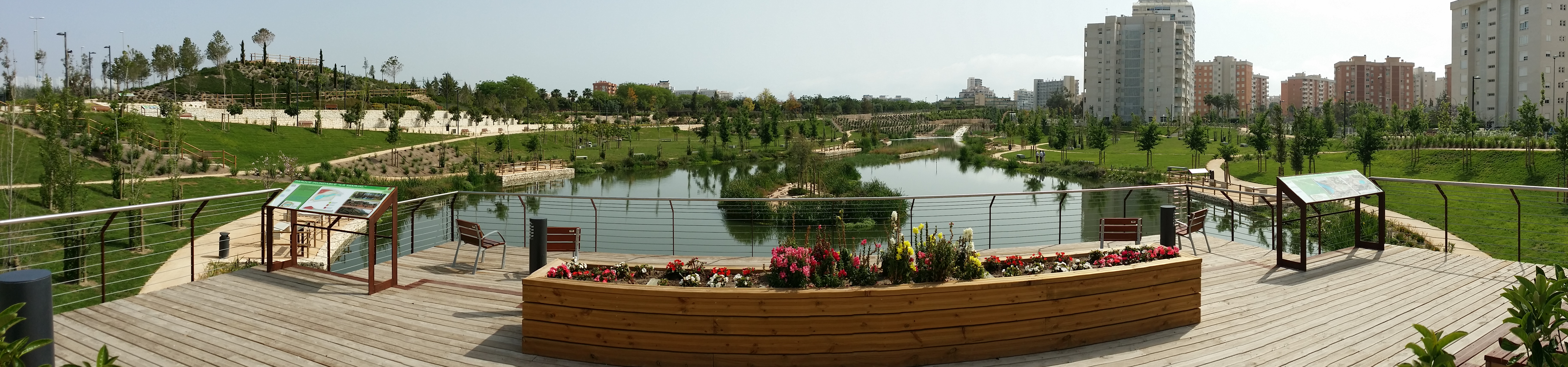
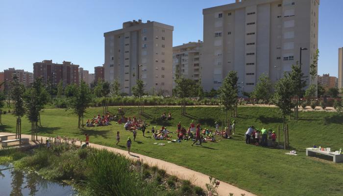
It is a unique green infrastructure in Spain, designed to prevent flooding, with a capacity to store up to 45,000 m³ of water, while also functioning as a recreational green area with strong social and environmental value. Since its implementation, the park has successfully resolved the recurrent flooding problems in this area while creating a new sustainable urban green space, home to native birds and flora. Additionally, the stored water is used for irrigating parks and gardens, which has contributed to a threefold increase in the city's green areas in recent years.
La Marjal Flood Park is located in an urban area, a short distance from San Juan Beach.
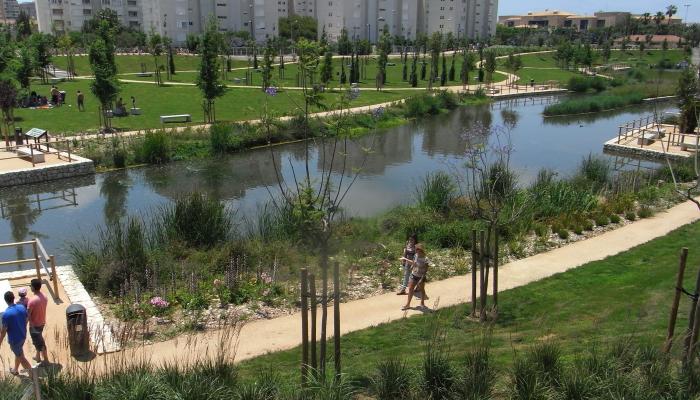
It is a unique park developed on former marshland that, in addition to the leisure and recreational functions of any park, also fulfills a hydraulic function: in the event of heavy rains, it serves as a rainwater retention basin, reducing the risk of flooding in the lower part of this area of the city.
It is an alternative solution that avoids the construction of new discharge channels into the sea.
The park is located on a municipal plot of 36,700 m² classified as a green area, forming part of a network of plots with the same classification that make up the larger Urban Park of Playa de San Juan.
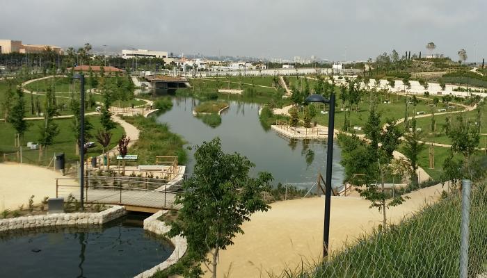
The natural terrain, which is practically flat, was modified to form a large water retention basin and, taking advantage of this feature, a varied topography was created that serves as a foundation for a series of elements that provide a wide variety of spaces, views, and perspectives. These elements enhance both the educational and informational interest of visitors and the biodiversity of the flora and fauna that have established themselves there.
The design of the park is based on the natural function of marshes, depressions, or plains separated from the sea by a chain of dunes that, during the rainy season, accumulate flows from their natural basins, generating coastal wetland habitats.
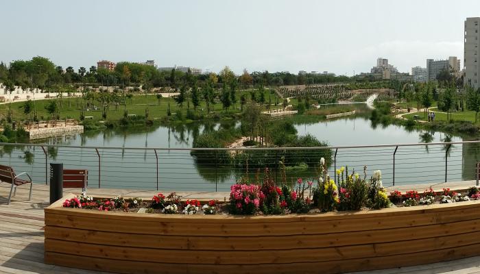
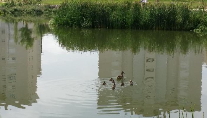
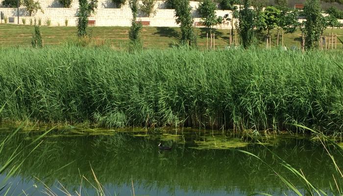
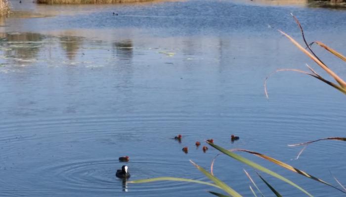
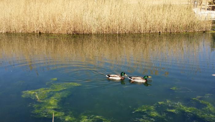
Inside the retention basin, there is a large pond surrounded by aquatic vegetation where visitors can observe the flora and fauna of the Valencian marshes (ducks, coots, herons, etc.). To keep the water in optimal condition, there is a recirculation circuit that includes a waterfall, a small pond, and a rapid.
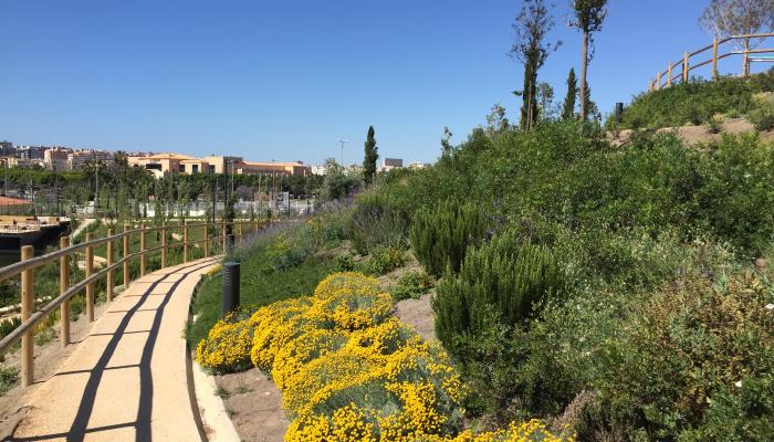
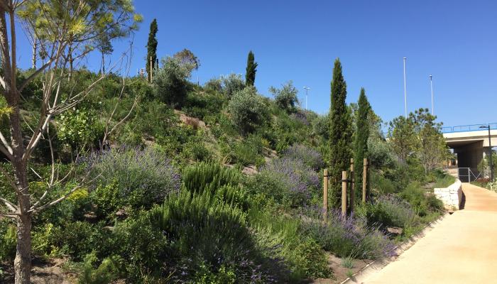
A hill formed using the soil excavated from the retention basin provides excellent views of both the park and the surrounding area, while also replicating the mountain vegetation and the Mediterranean agricultural landscape.
The park also features a highly advanced intelligent surveillance system that provides warnings to citizens and coordinates with security services for evacuation in the event of heavy rain forecasts.
Alicante is a pioneer in the use of innovative natural solutions to address urban challenges, aligning with the European Union's (EU) Horizon 2020 programme and its promotion of the Circular Economy. In this sense, the "La Marjal" park meets several priority objectives for the city, which are in line with those promoted by the EU:
The environmental impact of a new direct discharge point to the beach is minimized, ensuring that the beach's appearance is not negatively affected while solving flooding problems.
The environmental impact is also reduced by reusing a significant portion of the construction waste and excavation material from the ponds for the formation of the hill, different levels, and park pathways.
Flood risks in urban areas are mitigated, preventing significant personal and material damage.
The costs of the hydraulic works are lower compared to those required for constructing a new direct discharge collector.
The recovered water in the park is used for irrigating the park’s greenery and ponds, as well as other nearby green areas.
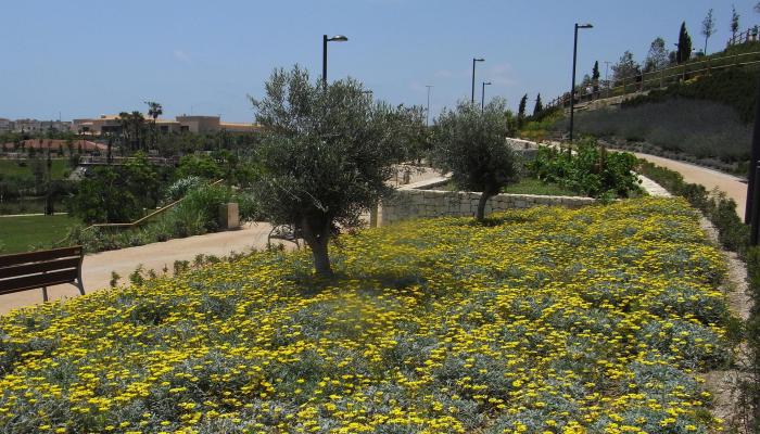
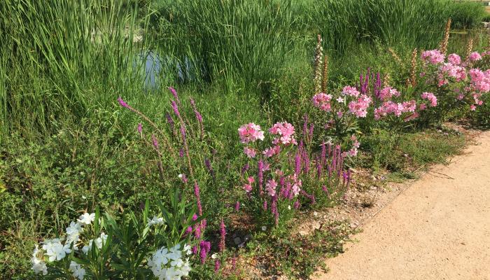
A new green area is created, prioritizing native vegetation throughout the park, which also serves an educational purpose, showcasing the various plant communities of the Mediterranean environment.
The social return on investment is optimized by allocating a significant portion of the budget to creating a new public space, which can be immediately used and enjoyed by citizens, remaining closed only for security reasons during heavy rainfall events and for short periods.
- Natural biodiversity is enhanced, creating an environment that attracts and supports colonization by some endangered species and the establishment of stable colonies.
The start-up of the "La Marjal" flood park represents the development of an innovative solution to the recurring floods that occur during heavy rains in the low-lying area of the city, particularly in the surroundings of Avenida del Pintor Pérez Gil, Calle Fotógrafo Francisco Cano, and the railway tracks near Playa de San Juan.
The essential idea of the solution is based on the natural function of marsh systems, which regulate water cycles and are frequent throughout the Mediterranean coast. The solution involved the construction of a large temporary rainwater retention basin, designed as a semi-buried concrete pond that acts as a storm tank.
From here, a comprehensive hydraulic system was designed so that, during an episode of heavy rain, when the capacity of the existing rainwater network is exceeded, the excess water is diverted to this storm tank within the retention basin.
The configured pond is primarily a decorative element, playing a role in the hydraulic function of the park only as a rainwater reception element, allowing the retention basin to gradually fill. If its capacity is exceeded
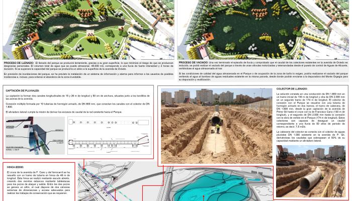
The rainwater collection is carried out through a system consisting of two longitudinal channels, 15 and 26 meters in length and 50 centimeters in width, located next to the curbs of the sidewalks on Avenida del Pintor Pérez Gil. These channels direct water into a large reinforced concrete evacuation collector through a network of multiple connection pipes. The captured water flows into a dual-tank system, from which a pipeline originates, serving the purpose of diverting excess flow from the existing municipal collector network to the park.
This diversion collector has two sections: a head section, 130 meters long (DN 1,800 mm), extending from the Avenida del Pérez Gil catchment point to the junction with Calle Francisco Cano, and a second section, 174 meters in length (DN 2,000 mm), connecting to the discharge system in the park.
The junction with Calle Francisco Cano and the railway tracks was managed using a piling pipe section, constructed via an open shield method, spanning 48 meters. The driving process involved creating two watertight enclosures using sheet piles for the entry and exit shafts, between which a siphon was formed, including two end chambers of adequate dimensions with access points for required maintenance work.
With its two sections, the collector leading to the park can drain a flow corresponding to a 50-year return period rainfall, equivalent to 7.5 m³/s.
The rainwater enters the park beneath the viewpoint at the head, and its filling process occurs slowly, thanks to its large surface area, which minimizes the risk of harm to people. The total volume of water it can store is about 45,000 m³, which corresponds to heavy rainfall lasting two hours. If this volume is exceeded, the surplus flow overflows through openings in the enclosure walls towards Avenida de Oviedo, which collects it and channels it to the sea.
When the rain stops and the flow in the existing network is reduced, the remotely controlled opening of a DN 1,200 mm gate valve allows the water retained in the park to be gradually released back into the existing network for discharge into the sea. If water quality conditions or the occupancy of the bathing area on the beach require it, the park can be emptied by diverting the water through a 1,200 mm diameter pipe into the collector on Avenida de Oviedo or through a 500 mm diameter pipe that connects to the existing wastewater pumping station on the same plot, from where it can be sent to the municipal treatment plant of Monte Orgegia for purification and reuse.
In anticipation of possible full flooding of the retention basin during extreme events, the park has an advanced intelligent surveillance and alarm system to inform users and initiate evacuation of the flood zone if necessary.
As mentioned above, the park is located on a municipal green space, a nearly flat plot of about 36,700 m², which has been modified to form the water retention basin and to create a varied topography that acts as a support for the development of different areas and elements.
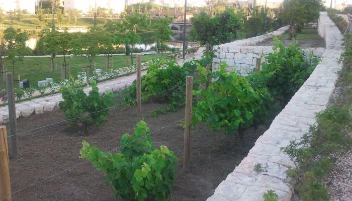
Landscaped accordingly, this park recreates the characteristic landscapes of riversides, mountains, and agricultural terraces typical of the region. No insecticides are used within its enclosure, thanks to the nests of swallows, swifts, and bats that have colonized the area, as well as gambusias in the ponds, which eliminate mosquito larvae and other insects.
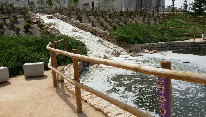
It has two water ponds: a small one, with a surface area of 338 m², whose water surface is at an altitude of 6.20 m above sea level, and a larger one, covering 6,674 m², with a water surface at an altitude of 2.70 m above sea level. Both are waterproofed with an EPDM liner to maintain an adequate water level and prevent the excessive proliferation of vegetation. They are supplied with reclaimed water and operate in recirculation through a pumping system that draws water from the bottom via 30 intakes, propelling it to the top of the small pond, from where it falls as a 4.20 m-high waterfall.
The waterfall features a vertical garden that conceals the supporting wall and a rockery that generates strong turbulence in the water, contributing to its oxygenation. Around the smaller pond, there is an area equipped with benches and fitness equipment.
Both the smaller pond and the waterfall are located outside the retention basin and serve a dual purpose: ensuring adequate aeration of the water in the ponds and creating a tranquil space for contemplation. This location also offers the best views of the park.
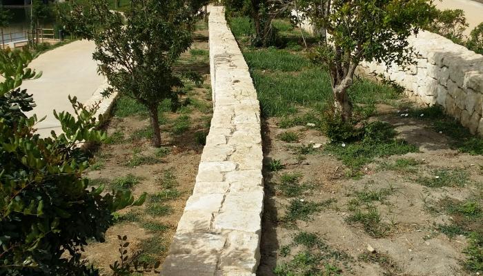
To the northwest of the park, there is a 20-meter-high hill, built using about 20,000 m³ of excavated soil from the retention basin. Another 40,000 m³ were used to landscape an adjacent municipal plot designated as a green area within the Urban Park of Playa de San Juan. On its southern slope, masonry walls were built, resembling the traditional agricultural terraces found in Alicante’s mountain areas.
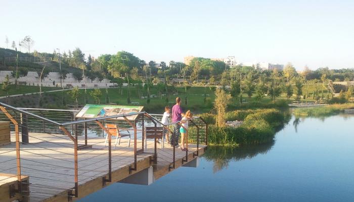
As a means of communication and connection with the rest of the Urban Park of Playa de San Juan, the park includes a 2-meter-wide, 28-meter-long pedestrian walkway. It crosses over the railroad tracks in the area, and to enhance the hedges that border the park’s paths, a vertical garden was added to its parapets, providing users with a sense of continuity between both areas of the park.
The most characteristic element of the park is the large pond, which remains as a permanent body of water, occupying the bottom of the flood basin and recreating the image of the original marsh. It contains two islands, serving as bird nesting areas and adding both ecological and aesthetic value to the park. Aquatic vegetation has been planted around it.
A perimeter path and several viewpoints allow visitors to closely observe the flora and fauna of this habitat.
The park is an example of sustainability, as all planted species (including olive trees, almond trees, pomegranate trees, carob trees, rosemary, thyme, and lavender) are irrigated using a drip system with reclaimed water from the Monte Orgegia treatment plant. All species are resilient enough to withstand submersion for up to 48 hours in the event of a heavy rainfall episode filling the retention basin.
Additionally, various aquatic and wetland-associated birds have been observed in the park, including some specially protected species, such as the kingfisher (Alcedo atthis). To encourage their presence, nesting sites have been installed within the park.
The development, construction, and management of the "La Marjal" Urban Floodable Park is the result of a public-private collaboration between the Alicante City Council and the company Aguas Municipalizadas de Alicante E.M.
The management of the park as a stormwater retention basin is carried out by Aguas de Alicante, a joint venture concessionaire responsible for the operation of the city's sanitation and drainage network. Through a remote control system, Aguas de Alicante monitors in real-time the water level in the retention basin, the flow circulating through the rainwater network, and any water that is diverted to the park. In the event of rainwater ingress, an acoustic and voice alarm system is activated to warn visitors.
Aguas de Alicante is also responsible for an important educational initiative on the operation of the park. It has developed an educational program with guided tours designed as a learning resource for schools, including the identification of the flora and fauna present in the park.
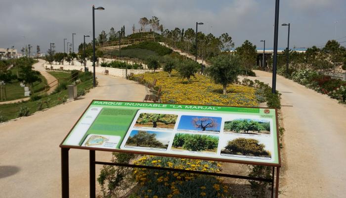
To this end, various information panels have been installed along the park’s pathways, providing details not only on its hydraulic function but also on the vegetation types characteristic of the three natural habitats recreated in its design (mountains, wetlands, and agricultural terraces).
The management and maintenance of the park as a public recreational space is carried out by the City Council through its regular gardening and ornamental fountain maintenance services, with a computerized system that integrates garden irrigation and pond water conservation.
The design of the park is based on the functioning of Mediterranean marshes, serving as a European-level model of effective public space management, green areas, and the conservation of endangered species. It also constitutes a unique example of a sustainable urban solution to flood risks.
Its approach is closely linked to the fact that in Alicante, flooding caused by intense and/or torrential rainfall is the most frequent and damaging natural hazard, resulting in significant material and human losses. It is also the risk that has required the greatest economic investment to mitigate.
Through its implementation, the city has significantly reduced these risks while simultaneously creating a new green public space for citizens and an exhibition site showcasing Alicante’s landscapes and ecosystems, with the colonization and habitation of numerous native flora and fauna species.
In addition, the La Marjal Flood Park has become a benchmark and a valuable educational resource for understanding flood risk management, the dynamics and processes of urban environments, and nature-based solutions to urban challenges. It enhances public awareness of flood risks and the importance of such natural systems.
In this regard, the project holds multiple educational values:
It helps analyze and understand the urban environment of the city and its socioeconomic evolution (from a rural economy to a service-based economy, particularly tourism).
It provides insight into why flood risks occur, in relation to urban expansion and the increased exposure of the population to these hazards due to the occupation of flood-prone areas, in alignment with the Mediterranean climate.
It serves as an interactive learning space, featuring information panels that explain how the park absorbs flooding, the areas affected at maximum capacity, and where the stored water would overflow in the event of extreme conditions.
It demonstrates emergency response protocols, including evacuation procedures during torrential rainfall episodes, utilizing the park’s video surveillance and alert system. This provides valuable public education on environmental awareness and flood risk management, helping to reduce vulnerability.
It showcases a green space with numerous Mediterranean plant and animal species, complemented by educational displays throughout the park.
It is an exemplary model of environmental sustainability in an urban park, featuring native species adapted to the region, irrigated through drip systems with reclaimed water, and spontaneously colonized by marshland fauna. No insecticides or chemicals are used, as natural ecological processes regulate insect populations and other species.
In summary, La Marjal Park is a pioneering green infrastructure that serves a triple function:
Hydraulic: Acts as a temporary rainwater storage area, reducing flood risks in the region.
Environmental: Functions as a green lung for the city, enhancing biodiversity by providing a habitat for marshland flora and fauna.
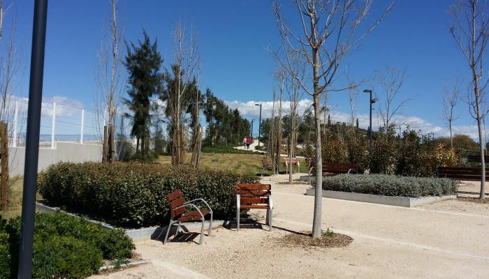
Social: Offers a recreational space for citizens, with facilities such as a viewpoint, fitness equipment, and a pedestrian walkway connecting to the Urban Park.
The park gets its name from the Mediterranean marshes, which act as reservoirs and accumulators of surplus flows from their natural basins, regulating water cycles in coastal areas.
In this sense, it is worth highlighting the innovative nature of this alternative, which serves as a novel proposal and can be used as a reference model for addressing flooding issues in other flood-prone urban areas, which are frequent along the Mediterranean coast.
On the other hand, it is a park designed for public enjoyment and use, ensuring free access for people with disabilities. To this end, the entire network of paths and trails has slopes of less than 6% and protective elements, organized around a 3-meter-wide main road surrounding the retention basin, from which secondary paths lead to other areas and facilities.
As a public space, to ensure the safety of visitors during heavy rainfall, both the park and the drainage network are permanently monitored and controlled by the Alicante Water Control Centre. In addition, a comprehensive protocol has been established for actions to be taken in case of flooding. However, the park does not fill instantaneously. This protocol can be summarized in three main actions:
Daily weather report dispatch to personnel involved in risk management and park monitoring systems, six days in advance.
Real-time notification of the onset of rainfall in the park area.
Real-time communication to risk management personnel and park monitoring systems regarding the start of filling and subsequent evacuation.
To support this, a comprehensive and intelligent coordinated control and warning system has been developed, consisting of:
Flood warning systems in the park.
Weather forecasting system for rainfall in the area.
Flow meters in the drainage collectors directing rainwater to the park.
Rain gauges for real-time measurement of precipitation.
Security cameras.
Large electronic display panels for public information.
Acoustic warnings with multilingual voice messages and sirens within the park.
On the other hand, the park has already proved effective in several heavy rainfall episodes, successfully preventing flooding. The largest events occurred in March 2017—when 140 l/m² fell within two hours of torrential rain—and in August 2019, when 87 l/m² were recorded overnight. The March 2017 event was the third-largest rainfall event since 1934 (after 1982 and 1997), while the August 2019 event marked the highest recorded rainfall in Alicante since 1859.
The park’s flood retention and regulation system performed effectively, collecting 15,500 m³ of rainwater in 2017, equivalent to 34% of its maximum capacity, and 22,000 m³ in 2019, approximately 50% of its total capacity.
The "La Marjal" Flood Park project has received numerous awards for its originality and impact, including:
Best Integration in the Environment and Environmental Respect Award of Alicante province, awarded by the Federation of Public Works of Alicante (FOPA), in 2015.
Alhambra Award, granted by the Spanish Association of Public Parks and Gardens, also in 2015.
In 2016, "La Marjal" was nominated for the Habitat Award for Good Practices, awarded by the UN every two years. Additionally, it has been recognized by the #PorElClima Community as a pioneering nature-based solution to urban flooding.
To mitigate the effects of future DANA storms, and following the example of La Marjal, the Alicante City Council and Aguas de Alicante plan to construct three additional green spaces with similar characteristics, along with a dozen high-capacity retention tanks, to discharges into the sea
As limiting factors, it should be noted that the maximum depth of the large pond is only 1.10 m, as it is necessary to keep the waterproofing sheet above the water table of the natural terrain, which is very scarce due to its proximity to the sea. This shallow depth causes the water temperature to reach 30 ºC in summer, which together with the strong sunshine endured, produces two undesirable effects: the decrease in the level of dissolved oxygen and the proliferation of filamentous algae.
To avoid these phenomena, periodic water analyses are carried out, with a dissolved oxygen level meter and a system with 4 ultrasonic emitters that prevent the proliferation of algae.
The total cost of the project finally amounted to the amount of € 3,307,855.56, VAT not included, being financed in its entirety by Aguas Municipalizadas de Alicante E.M.
A project such as "La Marjal" Park is affected by numerous and varied regulations related to land management, construction, heritage conservation, urban planning, and flood prevention, among other areas.
In this sense, in recent years, as a result of the European Union’s strategies on biodiversity, green infrastructure, and related initiatives, with objectives defined for 2020, the use of green infrastructure such as "La Marjal" has been progressively incorporated into state, regional, and municipal regulations.
In general, the project has been subject to various regulations at the local, regional, national, and EU levels, including:
the General Municipal Plan of Urban Planning of Alicante of 27 March 1987 (PGMOU, 1987)
Anti-flood plan for the city of Alicante of 1997
Directive 2007/60/EC of the European Parliament and of the Council of 23 October 2007 on flood risk assessment and management
Royal Decree 1620/2007, of 7 December, which establishes the legal regime for the reuse of treated water
Royal Legislative Decree 2/2008, of 20 June, approving the revised text of the Land Law
Royal Decree 903/2010 of 9 July 2010 on flood risk assessment and management (transposition of Directive 2007/60/EC)
Decree 1/2011, of 13 January, of the Consell, which approves the Territorial Strategy of the Valencian Community (ETCV)
Law 5/2014, of 25 July, on Territorial Planning, Urban Planning and Landscape, of the Valencian Community
- the Territorial Action Plan of a sectoral nature of the Flood Risk of the Valencian Community (PATRICOVA) 2003 (revised in 2015)
The initial idea for the Park was conceived in 2011. The Project was drafted in 2012 by the municipal technicians Manuel Beltrá Martínez (Architect), Joan Antoni Ferrando Pérez (Industrial Engineer), Carlos Domínguez Herrera (Agricultural Engineer), Lázaro López Andrés (Civil Engineer), Juan Carlos Ramón Penalva (Topographic Engineer), and Iraida Camarasa Beviá (Public Works Engineer), and was approved by the Local Government Board of the Alicante City Council on October 29, 2012.
The works began on April 5, 2013 and ended on March 27, 2015, with a total duration of 23 months.
Ferrando, J.A. 2016. "La Marjal" flood park. - A unique rainwater retention tank. PARJAP Journal, 83: 5-12.
Sánchez Zaplana A.; Simón Pla D.; Morales Belvis, J. 2016. Natural solutions for urban challenges in the city of Alicante. II Smart Cities Congress. pp: 257-262.
Morote followed A.Fr. 2017. The "La Marjal" flood park in Alicante (Spain) as a didactic proposal for the interpretation of flood risk spaces. Didáctica Geográfica nº 18, 2017, pp. 211-230.
Carlos Domínguez Herrera
Head of the Department of Green Areas
Alicante City Council
C/ Arzobispo Loaces, 13
03003 Alicante
Email: carlos.dominguez@alicante.es
Telephone: 965 107 476