

The ecological improvement of the Órbigo River is one of the most ambitious projects of the National River Restoration Strategy (ENRR), which involves recovering and improving both the lateral fluvial areas and the dynamics of the river and the longitudinal connectivity of its 108 km in length, from its source in the province of León by confluence of the Luna and Omaña rivers. to its mouth in the Esla River, in the province of Zamora.
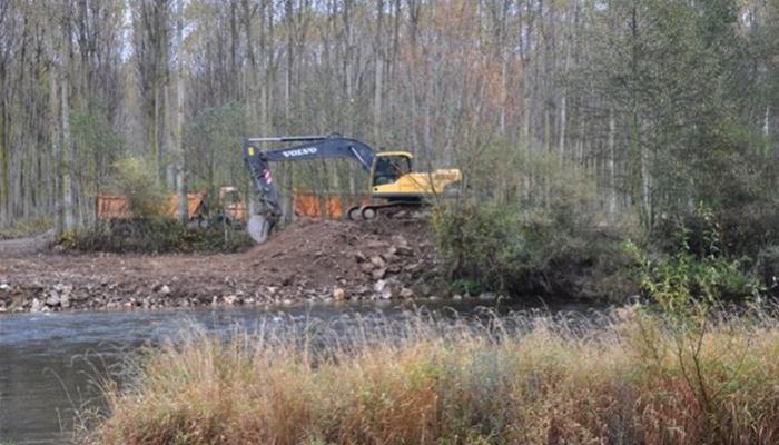
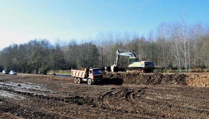
The project involves the intervention through three different phases of action, having concluded the naturalization works of the upper section (Section I), about 23.5 km long, with the elimination of embankments and breakwaters, reforestation of riverbanks and recovery of canals and adjacent river areas, with a high natural capacity to mitigate floods.
Its development included an important process of public participation where the local population was involved, managing conflicts that arose with the inhabitants of the affected riverside towns.
The channelling of large river sections and the existence of numerous longitudinal and transverse obstacles located along the river course of the Órbigo River motivated its choice to be the subject of an ambitious restoration project. It is not that the Órbigo is an exception, in fact this pattern of transformation and occupation of the river space, to a greater or lesser degree, occurs in all the large Spanish rivers. But due to a series of issues of opportunity, this river was selected to be part of the first contingent of projects of the National River Restoration Strategy (ENRR).
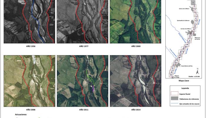
Before being subjected to all kinds of transformations, the river had a morphological structure with a braided and wandering pattern, probably due to an increase in runoff and sediment flows in the catchment basin and the lack of stabilization of the sediment bars as a result of intense exploitation of the catchment and riparian vegetation. This structure has to do with hydrology, erosion and also with the use of the riverbanks as a source of firewood and a place for grazing.
From the middle of the twentieth century, a profound transformation of the river space took place through its occupation and systematic reduction, especially with poplar crops. This entails levelling, destruction of secondary branches and a progressive simplification of the original river structure, braided as mentioned, and its replacement by a single narrow low-water channel, riddled with specks to prevent the flooding of the land occupied by crops. All these problems and obstacles altered its dynamics and disconnected the riverbed, banks and floodplain. The actions that were carried out were an example of the trend imposed throughout the twentieth century to solve the problems of flooding and high water, through regulation and channelling works.
These structural solutions are costly both in terms of ecology and construction, and above all maintenance. Something that works in very specific cases (consolidated and exposed urban sections, protection of infrastructures, etc.) is incompatible with living systems of periodic flooding, and very negative in rural sections where the pressure is low and very localized.
In this sense, the application of this management model channelled a large part of the Órbigo riverbed, causing a notable increase in the speed of the flows and generating incision and a whole series of negative impacts downstream.
In view of this, the main challenge of the proposed restoration project is to recover the river space and the capacity to mitigate possible floods of the alluvial plain, which have been systematically invaded and hydrologically disconnected from the main stream.
From a socio-economic perspective, the advantage of promoting the natural lamination of floods more in line with the river's hydrological-hydraulic nature is that it saves on expensive works and avoids damage to urban sections.
From a socio-economic perspective, the advantage of choosing to promote the natural lamination of floods more in line with the hydrological-hydraulic nature of the river consists in saving on expensive works and avoiding damage to urban sections.
The essence of the project is to "flood to avoid dangerous flooding", i.e. to prevent urban or urban areas from suffering flood damage, flooding of compatible areas must be allowed.
In hydrological terms, an increase in concentration times and a decrease in maximum flows can be achieved, achieving a higher infiltration rate and recharge rate of the alluvial aquifer and achieving a greater diversity of habitats, recovering a series of areas adjacent to the stream such as secondary channels, sidebars, drainage deltas, wetlands of meanders, ... which contribute to improving the biodiversity associated with river ecosystems and related ecosystems.
In this sense, one of the long-term objectives would be to promote the progressive substitution of arable crops by forest crops in flood zones, typical of areas subject to extraordinary floods, capable of withstanding them and improving the supply of silt and irrigation of these lands. The public hydraulic domain, that is, the land subject to ordinary floods would be reserved for natural riverside vegetation.
Another project objective is to reduce the number and intensity of riprap infrastructures, mounds and dams installed and/or necessary in the riverbed, reducing the cost of investments in this regard and dedicating the amount to other river ecological improvement and regeneration work.
The project to improve the ecological nature of the Órbigo River is very ambitious and wide-ranging, covering the entire length of the riverbed, around 108 km in length.
The phases of the project are as follows:
- Preliminary flood risk assessment.
- Project.
- Public participation and information.
- Environmental assessment.
- Final Project.
- Construction work.
- Monitoring and preparation of flood risk maps.
The original project includes 3 sections, of which only the first has been fully executed, to which should be added parts of sections II and III carried out with small actions in riverbeds.
The actions carried out include:
- Works to improve lateral connectivity and river dynamics
In section I, the following actions have been carried out on 23.5 km of river:
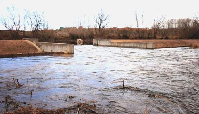
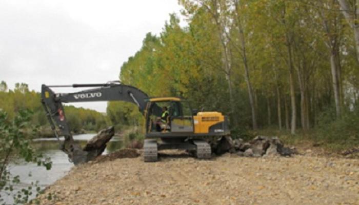
- Removal of breakwaters: 4,720 m.
- Mound removal: 8,710 m.
- Mound setback: 3,130 m.
- Secondary channel recovery: 10,063 m.
- Flood Area Recovery: 300 ha.
In section II:
- Mound removal: 1,550 m.
- Mound setback: 70 m.
In section III
- Speck removal: 950 m.
- Work to improve longitudinal continuity:
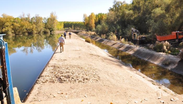
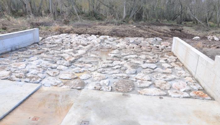
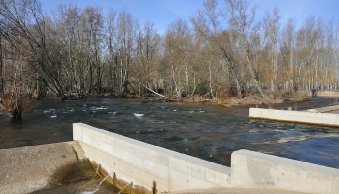
- modification of the Alcoba dam to allow the passage of fauna and flow of nutrients and sediments, a small dam about 2.5 m high and 165 m long, which constitutes an obstacle in the channel, but which is essential to conserve because it is the extraction point of the General Páramo Canal that supplies irrigation water to some 17,000 ha of land and to the city of León.
The works consisted of lowering the height in its central part, allowing an opening of about 15 m in length and 2 m in height, providing a ramp to facilitate the migratory passage of aquatic fauna (especially fish), which is installed during the irrigation season and removed during the rest of the year.
- Forestry actions:
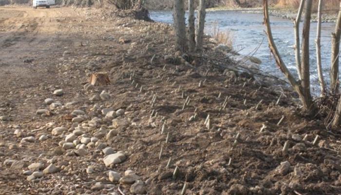
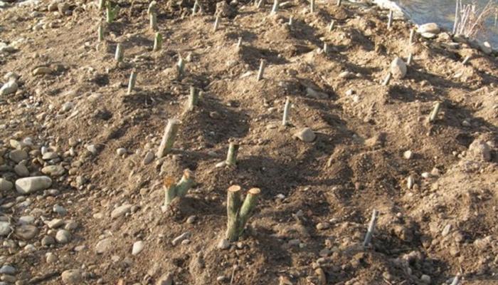
- Revegetation with riparian vegetation: 7.2 ha.
In this way, areas cleared of mounds and breakwaters were recovered, planting riverside vegetation characteristic of the area.
The transverse and longitudinal connectivity of the river has been recovered, as well as the natural lamination capacity, recovering 480 ha of floodplain. This reduces the danger of flooding and improves and regenerates river habitats under economic and environmental sustainability criteria. Secondary branches of the river with a total length of 10 km have also been recovered.
On the other hand, a stretch of about 25 km in length of river has been reconnected, allowing the migratory passage of native aquatic fauna, particularly fish, as well as sedimentary nutrients. More than 70,000 m2 have also been reforested with riparian vegetation plantations, recovering flood-prone alluvial areas, which act as flow and flood regulators, and nutrient capturers.
As a whole, the actions have led to the recovery of a more natural fluvial dynamic, contributed to improving the river's ecological status, and increased its resilience to the impacts of climate change.
A fundamental aspect of the project has been and is the public participation by the population of the affected localities, with informative meetings for the solution of problems and for their territorial integration. The purpose is to show the benefits of the project, also showing that it is possible to address a reduction in the risk of flood damage through non-structural measures, overcoming possible barriers and obstacles. In addition, the project, once executed, has contributed to bringing the river closer to the population, who have managed to access the banks in recreational areas where it was not possible before due to the presence of mounds or breakwaters.
The data obtained have been used to provide feedback to the decision-making process by the project managers and will be the basis for future actions, in lower sections of the Órbigo River, as well as in other rivers.
The project was drafted, prepared and executed by the Duero Hydrographic Confederation, with the collaboration of the Autonomous Machinery Park Organism of the former Ministry of the Environment, Rural and Marine Affairs - MARM (today the Ministry for the Ecological Transition and the Demographic Challenge - MITERD).
However, other stakeholders involved in its preparation, monitoring and control were the affected local populations, who actively participated from the first previous actions as early as 2009, through informative meetings with Mayors and Neighborhood Councils (preparatory phase). This participation and monitoring was constant during all phases of implementation, from the diagnosis phase to the public exhibition and execution, providing data, discussing intervention alternatives and seeking consensual and operational solutions for all.
The project is an example of an integrated application of the European Water Framework Directives (2000/60/EC) and flood (2007/60/EC), which led it to be a finalist for the European Riverprize in 2013, convened by the International River Foundation that recognizes the most outstanding actions in river management, one of the most prestigious awards in environmental matters.
In any case, the proposed regeneration project and the execution of its first phase have been the main work carried out by the Duero Hydrographic Confederation, both for its dimensions and for its co-participatory nature with the local populations, being an example that can be extrapolated to many other rivers.
In this sense, in addition to the actions carried out on the riverbed and banks themselves (elimination of obstacles, recovery of secondary arms, improvement of hydraulic capacity, connectivity with the floodplain and reconnection of river continuity), the intense work of information and public participation carried out stands out, with constant collection of data and feedback in the face of modifications or partial interventions during its development.
In short, the general approach of the works and actions planned and executed (Phase I) improves the hydraulic conditions of the stream and its ecological conditions inseparable from the reduction of flood risks and the enrichment of its banks, promoting the exploitation of controlled production of populiculture.
The project, in particular in Phase I executed, involves a series of actions developed in the upper section of the river, which involve:
- The demolition, removal and removal of the main bed from possible barriers and lateral obstacles, mainly embankments and rock reinforcements.
- The recovery of canals, secondary beds and wetland alluviums, with the purpose of improving the hydraulic capacity and diversity of river and riparian habitats.
- Connectivity with the collateral floodplain, favouring the ability to attenuate floods.
- The improvement of the continuous longitudinal connection of the river, eliminating and/or modifying transversal obstacles such as the Alcoba dam.
- The arrangement of structures or ramps for fish.
In short, with the interventions carried out during this first phase:
- Action has been taken on some 26 km of river, rearranging or eliminating all the infrastructures and obstacles located in the riverbed, removing 11.2 km of motes from it and setting back another 5.22 km of motes outside the river territory, placing them next to the elements to be protected (homes or infrastructures).
- 4.72 km of breakwaters have been removed.
- The Alcoba dam has been permeabilized by the central opening of it over a 16 m section, adopting a dismountable system by means of profiles and planks so that during the salmonid migration seasons the dam is completely remountable, allowing the reconnection of about 25 km of river.
- About 1,100 m3 of waste have been removed.
- In some areas, cutting-based engineering techniques have been applied along 1.4 km of river.
- The restored sector has increased its dynamism and sinuosity, showing that the plant communities that have recolonized its banks are similar to the original ones of the channel, with a greater degree of naturalness than in other sectors of the river that have not yet been restored. All this shows that the restoration has been moderately effective in the short term from an ecological point of view, although in order to know the degree of effectiveness in the long term, the evolution of this river must be continuously monitored
With regard to the limitations of the project, it should be noted that the other two phases proposed have not been carried out, due to organisational issues, budgetary availability and timeliness, which to date have not allowed their conclusion in accordance with the original initial approach.
The development of this first phase of the project (Phase I.- Demolition of barriers in the Órbigo River, to recover ecological connectivity), has had a total budget of € 3,100,000.
The project has been highly valued both at a technical level and at the level of participatory approach and management with the affected local populations, to whom it undoubtedly offers an improvement in habitats and river dynamics, a cover against the risks of overflows or floods and an economic opportunity to reduce land abandonment, favouring the exploitation of forest crops compatible with floods such as poplar plantations.
Directive 2007/60/EC on flood risk assessment and management recognises, in its Recital number 14, that Member States, when developing Flood Risk Management Plans, should consider the maintenance or restoration of floodplains. Article 7(3) provides that the management of these plans shall take into account the consideration of areas with the potential to retain floodwater, such as natural floodplains.
The Directive was transposed into Spanish law by Royal Decree 903/2010, of 9 July, on flood risk assessment and management. The annex, which deals with the content of the Flood Risk Management Plans, establishes that the set of programmes and actions must include both measures for the restoration of rivers, which lead to the recovery of the natural function of flood-prone areas and their associated environmental values, and measures for the restoration of hydrological and agroforestry systems in river basins in order to reduce the sedimentary load transported by the current, as well as favouring the infiltration of rainfall.
Consequently, and within the National Strategy for River Restoration and the Flood Zone Mapping System, promoted by the Ministry of the Environment, Rural and Marine Affairs - MARM (today the Ministry for Ecological Transition and the Demographic Challenge - MITECO), the Duero Hydrographic Confederation proposed and is carrying out this ecological restoration project on the Órbigo River.
The execution work of the project to demolish barriers in the Órbigo River to recover ecological connectivity began in October 2011, concluding in November 2013, with approximately 2 years of development.
Barquero Pérez J.P.; Santillán Ibáñez, J.I. 2012. The project for the ecological improvement of the Órbigo River (Section I). WILLOW, 15-17.
Rodríguez Muñoz I.; Santillán Ibáñez J.I.; Huertas González R. 2012. The Órbigo River Restoration Project and its implications in flood risk prevention. WGF Thematic Workshop: Stakeholder Involvement in Flood Risk Management. 17 - 18. April 2012. Bucharest-Romania. 9 pp.
Rodríguez Muñoz I.; Santillán Ibáñez J.I.; Huertas González R. 2012. Ecological improvement project in the Órbigo River. European Centre for River Restoration. CRRNEWS - 1/2012. 10 pp.
Huertas González R. 2014. River Órbigo Restoration Project: an example of synergic implementation of different European Directives. EUROPE-INBO 2014 Bucharest, Romania, November 2014 Workshop on River Restoration and NWRM. 15 pp.
Martínez-Fernández V. et al. 2017. Dismantling artificial levees and channel revetments promotes channel widening and regeneration of riparian vegetation over long river segments. Ecological Engineering, 108: 132-142.
Project videos:
Long version video: https://www.youtube.com/watch?v=5OSMCUvGJG8
Short version video: https://www.youtube.com/watch?v=RLEGKJX3fGk
Long English Version Video: https://www.youtube.com/watch?v=pgPzoHCGio0
Ignacio Rodríguez Muñoz
Duero Hydrographic Confederation
Water Police Station
C/ Muro, 5 – 47004 Valladolid
Email: irm@chduero.es
Telephone: 983 215 475