

The Manzanares River, as it passes through the historic Royal Site of El Pardo, has undergone various hydromorphological alterations over the years, profoundly transformed both the riverbed and its banks. These transformations have resulted in the significant loss of fluvial space, habitats diversity, both longitudinal and transversal connectivity of the river, and public accessibility to its banks.
In response to these challenges and in compliance with the European Union's Water Framework Directive, an ambitious restoration project has been initiated with the aim of improving the river ecological status. This project is aligned with the environmental objectives of the Hydrological Plan of the Tagus Hydrographic Demarcation and has the collaboration of National Heritage, which manages the Monte de El Pardo. The focus is on rehabilitating and enhancing this section of the river, which extends from the Pardo Reservoir to the confluence with the Trofa stream, covering approximately six kilometres.
This segment of the Manzanares River is catalogued in the Hydrological Plan as a water body of a "Highly Modified" nature. The intervention seeks not only to restore the river´s natural conditions but also to better adapt it to the expected effects of climate change, such as reduced flows and the increase in the frequency and intensity of extreme weather events. In addition, the recovery of an area of great environmental and cultural value is pursued, improving biodiversity, ecological functionality, and the public experience of the river.
The project directly addresses river restoration needs by implementing management practices that include reconfiguring the riverbed, restoring riparian vegetation, and improving the river's connectivity and accessibility for citizens and local wildlife. The techniques applied seek to reverse the negative impacts of past human interventions and create a more resilient and dynamic river corridor that can withstand current and future pressures.
With a vision towards long-term sustainability, this project not only improves the ecological status of the Manzanares River, but also serves as a model for future river restoration initiatives in other similar contexts, both nationally and internationally. The results of this project are expected to contribute significantly to the science of river restoration and integrated watershed management, providing valuable lessons on the interaction between human activities and river systems in urban and peri-urban environments.
The Manzanares River in the vicinity of the Royal Site of El Pardo has been affected over the years by a series of hydromorphological alterations that have led to significant changes in the conditions of both the channel and its banks. At first glance, the river appears as a succession of backwaters as a result of the existence of a series of barriers in the riverbed of different natures.
In particular, one of these barriers is a "pseudo-natural" dam that forms at the confluence of the Manzanares River with the Arroyo de la Trofa due to the accumulation of sediments (mainly sand) from the intense erosion of this stream´s basin. However, these are not the only alterations that affect the basin of both channels: the Manzanares river in the study section exhibits a hydrological regime where, on the one hand, the circulating flow is insufficient to mobilize the sediments at the confluence with the Trofa stream, on the other hand, the lack of sediments in this flow is creating incision problems along the entire section. Additionally, the loss of fluvial space and the high nutrient content has also been detected in the Trofa stream.
The aforementioned alterations are highly likely to be aggravated in a climate change scenario, where it is foreseeable that the usual flows will decrease and increase the frequency and intensity of flood episodes. When combined with rising temperatures, the most immediate expected effects will be the decrease and homogenization of the aquatic biotope, the increase in incision processes and greater eutrophy with the consequent development of helophytes and the decay of riparian vegetation.
And that is why this intervention is proposed, to adapt these water bodies and the associated ecosystems to the effects of climate change that can be simplified into three main phenomena:
The increase in temperatures will lead to further deterioration of the riverbed: with the eutrophication of its waters, the increase in the existing reeds and the increase in the mortality of the riverside forest.
The decrease in rainfall will mean that the reservoir upstream of this section will have a greater capacity to protect against floods, so that the river downstream will increasingly resemble a wetland with a constant flow. The absence of floods will encourage the silting up of the beds and the development of vegetation within the channel.
On the other hand, the phenomena of intense precipitation will have opposite effects on the basin of the Trofa stream, promoting greater erosion than currently exists.
- Contribute to the improvement of the ecological status of the Manzanares River and the Trofa stream and to serve as a pilot example of a climate change adaptation measure in the field of river management.
- Ensure compliance with environmental and hydrological objectives in accordance with current regulations (Hydrological Plan and Flood Risk Management Plan of the Tagus Hydrographic Demarcation)
- Restore of the hydrological, morphological, and ecological naturalness of the river (permeabilization of artificial structures, recovery of riverside groves and altered areas)
- Return the longitudinal and transverse connection of the channel.
- Recovery of accessibility to the riverbed, promoting public use.
- Bring the river closer to its users by adapting paths and optimizing the spaces for public facilities.
- Reduce the risks of flooding in the area and downstream, in the city of Madrid.
- Extend the environmental corridor of the Manzanares River (establish a meeting point between the city and the natural environment).
ON THE MANZANARES RIVER
Actions for the recovery and improvement of river habitat
- Prior to the permeabilization works on the barriers in the Manzanares River, native fish species have been rescued (captured and transferred).
- By placing rocks and/or logs in the river section, the number and diversity of refuge and reproductive microhabitats for aquatic organisms have been increased.
Actions to improve vegetation cover.
- Silvicultural work and removal of exotic vegetation. They include the sanitation of vegetation through pruning and clearing and, in some cases, removing specimens that are in poor phytosanitary condition.
- Restoration of riverside vegetation. Planting of irregular crops of native species, in bands parallel to the riverbed and protection of unique trees
Recovery and improvement of hydrological continuity
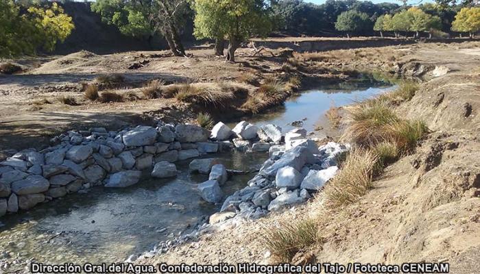
- Trofa sediment removal. The homogenization of the flow regime in the Manzanares River and the increase in erosive processes and discharges from several treatment plants in the stream basin had created a sediment island, which has been partially removed in search of a suitable slope for the bed that allows the original width of the river to be recovered.
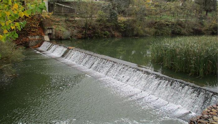
- Lowering slab station gauging. The foundation slab of the Mingorrubio gauging station was removed to reduce the level of the current bed and eliminate the backwater produced upstream.
- Installation of a fish ramp in the El Pardo dam to facilitate the migration of native fish species.
Morphological recovery of the riverside space
- Removal of fillings and slopes smoothing, improving accessibility to the river
- Restoration of the ravine of "Las Madroñeras – Freijo". The Madroñeras ravine is a complex of gullies used for the extraction of aggregates at the time of the construction of the El Pardo dam.
Sustainable public use and interpretation of nature
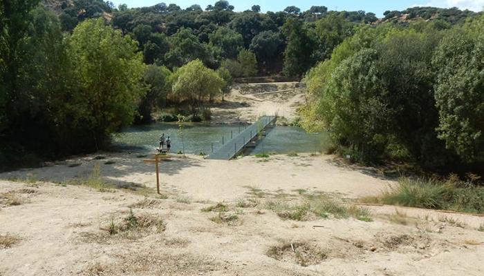
- Installation of a pedestrian walkway to recover pedestrian communication between both banks, eliminated with the demolition of the old Mingorrubio gauging station.
- Adaptation of paths and trails of several types. Those affected by the earthworks have been adapted to ensure the safety of users.
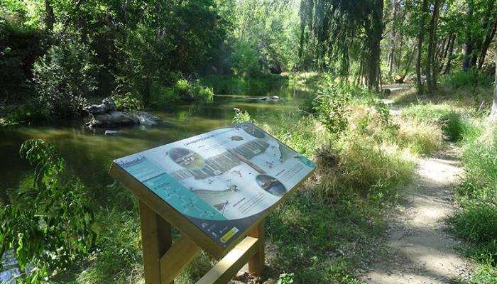
- Interpretive material and signage. Information panels have been placed showing the main natural and/or cultural characteristics of the river. In addition, the network of paths and paths has been signposted.
ACTIONS IN THE TROFA STREAM
Area limited to wildlife.
- Hunting enclosure. To minimise the causes of erosion, the area from the stream crosses the railway line to its mouth in the Manzanares River has been limited.
- Watering holes – ponds. Since the enclosure restricts the use of part of the stream basin, it is considered necessary to install watering troughs outside the enclosure.
- Enclosure at the confluence with the Manzanares River. At the confluence point, the fence that delimits the Monte de El Pardo periodically suffers breakages due to stream flooding. A permanent structure has been built, so that it can withstand the strong floods and allow the evacuation of large volumes of water and sand.
Bed lift and lateral reconnection.
- Installation of hydrotechnics. The mobilization of land and smoothing of slopes is facilitated, which raises the bed and enhances the functionality of the floodplain, favouring the connection of vegetation with the water table. These measures also contribute to sediments retentions, recovery of vegetation and natural purification of waters from the municipalities upstream.
- Sediment traps. To contribute to the stability of the materials provided in the earthworks, "fixed points" are established in the channel that, like a sediment trap, produce an upstream backwater.
Recovery of riparian vegetation and undergrowth
- In the band closest to the stream, ash trees have been planted with deep roots and it has been staked with willows, while in the areas furthest from the stream, bushes, shrubs, and trees of native species typical of the area have been planted.
- Phytopurification
- High nutrient values were detected due to the effluents that reach the stream. Macrophytes with high phytopurification potential have been planted, while a biotope of interest for avifauna and amphibians has been generated.
GENERAL ACTIONS
- Maintenance and conservation
- Crop Replacement
- Maintenance irrigation
- Road maintenance
- Sanitation of riverside vegetation
- Ecological and Environmental Monitoring
Over the next three years, the impact of the measures on the ecological status of the water body, the hydromorphological status, the state of the vegetation, etc., will be evaluated. The work already carried out in this regard has made it possible to design part of the actions to be conducted in phase 2 of the project.
Improving Ecological Resilience:
- Habitat Adaptation: The project directly addresses the adaptation of river habitats that are critical to local biodiversity. In response to the challenges of climate change, such as extreme temperatures and altered precipitation patterns, the restoration of these habitats ensures the survival and prosperity of native species, both flora and fauna.
- Water Resources Management: Adapting river management to expected changes in flow regime due to climate change is vital for maintaining the river´s ecological health, preventing eutrophication, and better managing water resources in the region.
Flood Risk Reduction:
- Flood Control: The project increases the river's capacity to manage more intense and frequent flood events, which is an anticipated effect of climate change. This reduces the risk of flooding, which can have devastating consequences for both ecosystems and nearby human communities.
Water and Biodiversity Conservation:
- Recovery of Natural Spaces: By restoring the continuity and natural morphology of the river, the project facilitates the creation and conservation of wetlands that function as important reservoirs of biodiversity and as natural water retention systems. These spaces are essential for adapting to water scarcity and maintaining the ecological cycles necessary in a changing climate.
- Promoting Administration: General Directorate of Water. Tagus Hydrographic Confederation (Ministry for Ecological Transition (MITECO)
- Collaborating administrations: General Directorate of the Spanish Office for Climate Change (OECC), National Heritage, Madrid City Council, Autonomous Community of Madrid.
- University: Higher Technical School of Forestry, Forestry and Natural Environment Engineering (Polytechnic University of Madrid)
- Research Centres: Centre for Studies and Experimentation of Public Works (CEDEX)
- Other entities involved: "El Pardo Neighbourhood Association" and "El Pardo en Común Neighbourhood Association".
After the drafting of the project, coordinated by the General Directorate of Water and the Tagus Hydrographic Confederation of the Ministry for Ecological Transition (MITECO), with the collaboration of the Spanish Office for Climate Change of MITECO, river restoration actions began on this section of the Manzanares River to achieve its environmental recovery and adaptation to climate change.
As for the population of the area, several meetings were held with the neighbourhood associations to explain the planned actions and resolve doubts about the execution. During the months of March and April 2017, a study was conducted to find out the assessment of the restoration project of the Manzanares River, the assessment of the environment, characterise visitors, and know the influx and habits of visitors.
A project website was created as one of the initiatives that promoted the dissemination of the project, allowing people to know the progress of the works and the results obtained.
An information booth of the project was installed next to the Somontes’ car park, where on weekends the public was informed about the river restoration actions that were going to be conducted.
This project is intended to serve as a pilot example of a measure of adaptation to climate change by promoting the management of the river environment.
Within the river restoration project of the Manzanares River in El Pardo (Madrid), a series of actions and guidelines for planning and managing of the space are included, in order to improve the state of the river and its nearby environment and guarantee its conservation and enhancement.
Given the enormous potential that the Manzanares River has for public use and environmental education, due to its proximity to the city of Madrid, it is considered of great interest to conduct.
The restoration of the river in the surroundings of the Royal Site of El Pardo, thereby contributing to the improvement of the ecological status of the river and the recovery of this space of significant environmental value.
In addition, in this first phase of the project, pilot actions have been incorporated on which subsequent monitoring established, which has made it possible to make an initial evaluation and redefinition of the actions for later phases. Phase 2 is expected to begin in the coming months, and these pilot actions have already been included in a more widespread way once their effectiveness has been proven, which can also be exported to other scenarios with similar problems.
One of the key aspects of the project has been to improve the citizens´ perception of the problems that threaten the river ecosystem and that result in those symptoms that they can see with the naked eye: dry vegetation, deepening and narrowing of the riverbed, areas of reservoir water... The project area is one of the most frequently used by the people of Madrid for leisure activities and from the beginning it has been considered a priority to inform the population to achieve acceptance and success of the project. To this end, various Information Days were held during the drafting phase and in the execution phase, explanatory posters have been installed and these information tasks will continue as the development of the project progresses.
Another fundamental issue is coordination and collaboration between administrations. This is a space where the competences of several administrations converge and achieving good coordination was one of the determining aspects when it came to achieving the project objectives. Thanks to the involvement of all of them, the project is being executed according to plan and it is expected that, in the coming months, once the environmental processing is completed, phase 2 of the project will begin, which extends from the confluence with the Trofa stream to the San Fernando Bridge (Madrid)
This is a project financed by the PIMA Adapta Plan (Plan to Boost the Environment for adaptation to Climate Change in Spain), with an investment of €2,151,798.62
The costs of this action are made up of the cost of the execution of the project. As for the benefits, they are those derived from the improvement that is achieved in the operation of the rivers, serving the objective of complying with the requirements of the Water Framework Directive, and also guaranteeing the provision of goods and services to society, including the reduction of the expected damage due to flooding and the costs allocated annually to the conservation of the public hydraulic domain, which will be significantly reduced.
The project is part of the Hydrological Plan for the Spanish part of the Tagus Hydrographic Demarcation, fulfilling the proposed hydromorphological measures, those related to the reduction of the pressures of regulation elements thanks to the improvements in river continuity and restoration that it comprises.
On the other hand, this section of the Manzanares River is identified as one of the areas of significant potential flood risk and the project complies with the measures contemplated in the Flood Risk Management Plan of the Spanish part of the Tagus Hydrographic Demarcation.
River restoration aligns with the objectives of the Water Framework Directive and the Floods Directive.
In addition, this section is within the Special Area of Conservation of "Cuenca del Río Manzanares" and in turn is a Special Protection Area for Birds "Monte de El Pardo", having a Management Plan that includes among its Guidelines on the conservation of Natural Resources several aimed at the fluvial restoration of its bodies of water and the improvement of the riverside vegetation.
The project has been subjected to environmental assessment and has been the subject of a Resolution of the Secretary of State for the Environment formulating the Environmental Impact Report of the project, which includes all the environmental requirements of the project. (Resolution of 10 October 2016, of the Secretary of State for the Environment, formulating an environmental impact report on the project River Restoration of the Manzanares River in the vicinity of the Royal Site of El Pardo (Madrid). BOE no. 259 of 26 October 2016)
November 2016 – November 2019
- Preparation of guidelines and orientations for the integration of climate change adaptation into ecological restoration and ecosystem connectivity initiatives in Spain. Rey Juan Carlos University, commissioned by the OECC.
- Preparation of a study on the integration of climate change adaptation in the planning and management of protected areas in Spain. González Bernáldez Foundation, EUROPARC-Spain, commissioned by the OECC.
- Preparation of the State Strategy for Green Infrastructure and ecological connectivity and restoration. MNCN – CSIC, commissioned by the DG for Quality, Environmental Assessment, and the Natural Environment.
- Forests and biodiversity in the face of Climate Change: Impacts, Vulnerability and Adaptation in Spain.
General Directorate of Water. Deputy General Directorate of Integrated Management of Hydraulic Public Domain.
- Francisco Javier Sánchez Martínez
- mail: fsmartinez@mapama.es
Tagus River Basin Authority.
- Lidia Arenillas Girola lidia.
- mail: arenillas@chtajo.es