Plataforma sobre Adaptación al Cambio Climático en España

You are here

Reconversion of former irrigated land into pastures in the area of Las Tablas de Daimiel National Park

Picture author: Parque Nacional de Las Tablas de Daimiel/AdapteCCa

The Tablas de Daimiel is a virtually unique wetland in Europe and the last representative of the ecosystem known as 'river tables,' once characteristic of the central plain of our Peninsula. It is a complex ecosystem that combines the characteristics of a floodplain, created by the overflows of the Guadiana and Gigüela rivers at their confluence, with an area of groundwater discharge from a large aquifer, resulting in the formation of a waterlogged river area: the river tables.

These overflows, facilitated by the gentle slope of the land, are accompanied by the development of a robust and distinctive vegetation cover, which provides an exceptional habitat for the fauna associated with aquatic environments.

The declaration of the National Park was a significant step forward in conserving one of the most valuable ecosystems in La Mancha, ensuring the survival of the bird species that use these areas for wintering, feeding, and nesting. An Integral Area for waterfowl was also established.

The Master Plan for the Use and Management of the Park (PRUG) has addressed some of the anthropic alterations caused in recent decades. A corrective measure has been the acquisition and conversion of former irrigated land into pastures characterised by the presence of holm oaks, grasses, wild legumes, and annual pastures, which are now used for sheep grazing.

Case Study Description
Challenges: 

Currently, the ownership of the land of the National Park (NP) of Las Tablas de Daimiel is entirely public, with some traditional infrastructures, such as fishermen's houses, being considered part of its cultural heritage. In the NP, there are no extractive exploitations, except for some occasional traditional extractions for the collection of reeds or bulrushes. However, thanks to the high piezometric level of the area, irrigated agriculture has been developed in some adjacent areas, in a region primarily characterised by rainfed crops. Part of this cultivated land invades the peripheral protection zone of the Park (5,410 ha), causing damage to the ecosystem and to the local and migratory fauna in that area. Additionally, the park has an area of socio-economic influence of 82,174 ha, which includes three municipalities.

Due to this issue, the Park has followed a very active policy of land acquisition in recent years, motivated in part by the rescue of water use rights, within the measures aimed at reducing the overexploitation of the hydrogeological unit in the area. In total, 1,106.50 ha have been acquired, and 3,128,871.10 m3 of potential irrigation rights have been recovered. Different files have also been processed for rainfed agricultural exploitation with traditional livestock use on properties in its Peripheral Protection Zone.

In this regard, the Master Plan for Use and Management (PRUG) of the National Park (NP) of Las Tablas de Daimiel, approved by Decree 87/2017 of December 5 (Official Gazette of Castilla-La Mancha of December 18, 2017), includes in Article 6.1.3 the following provisions, among others:

  • The acquisition of land in the peripheral protection zone for future expansions of the National Park will be maintained, prioritising the purchase of those adjacent to the national park or to properties owned by the Autonomous Agency for National Parks (OAPN), under the Ministry for Ecological Transition, which in turn border the Park.
  • The biodiversity of the national park will be enhanced by developing a programme for the restoration of terrestrial habitats, recovering a mosaic of different plant formations where pastures, patches of Mediterranean forest, or natural grasslands are interspersed.
  • For the regeneration of treeless areas intended for the formation of pastures, reforestation will be carried out with native plants of certified origin, planted randomly and always with individual livestock protectors to guarantee the maintenance of agroforestry use.

In alignment with the provisions of the PRUG and concerned about the effects that climate change may have on natural spaces such as the NP, the park administration proposed in 2017 the reforestation of an adjoining property that had been acquired a few years prior. To this end, it launched the project titled "Reconversion of old irrigated crop land into pastures in the Protection Area of the Las Tablas de Daimiel National Park," which was processed within the Plan to Promote the Environment for Adaptation to Climate Change (PIMA).

Given that the PIMA is a set of specific measures aimed at mitigating the damage that climate change may cause in our country and preparing for those that may foreseeably occur, and that among these measures is the implementation of forest management strategies to adapt to climate change by reducing and/or offsetting carbon dioxide (CO2) emissions, it was considered that the project fit perfectly into the philosophy of this Plan."

Objectives: 

The project primarily consisted of the reforestation with holm oaks of an area of 104 ha in the location known as La Duquesa, part of a former estate bordering the National Park, previously dedicated to intensive irrigation. The main objective of this action was to restore the land's original dehesa ecosystem, characterized by the presence of holm oaks, grass pastures, wild legumes, and annual pastures, which are usable for the grazing of La Mancha sheep. Additionally, the development of the restored dehesa serves as a mitigation measure by acting as a CO2 sink.

The area chosen for reforestation was in the National Park Protection Zone, identified as polygon 2, plot 6 of the municipality of Daimiel. It covered an area of 202.72 hectares, of which 104 hectares were reforested, slightly more than half. The land was acquired by the OAPN in December 2007 and had a petric calcisol (CLp) type soil with a carbonate profile, which is the most representative and characteristic lithology of the area.

The OAPN has been acquiring land in the protection zone of the National Park since 1999 (LIFE project) to create a buffer zone that mitigates the impacts of human activities in the area surrounding the protected site, particularly those related to intensive agriculture (such as groundwater extraction, pollution from inorganic fertilizers, and pesticides). In parallel, the goal is to promote environmental improvement, including the recovery of different terrestrial habitats that naturally existed around the National Park, while simultaneously increasing its biodiversity.

Since 2001, various efforts have been undertaken, including the afforestation of agricultural land, transformation of olive groves into forest areas, promotion of natural pastures, and restoration of the original unique pasture on limestone substrates that once existed in many areas. These actions align with the objectives of the afforestation works proposed.

In addition to the main objectives mentioned, the medium- and long-term goals of the project with the establishment of the new forest include:

  • Enhancing habitat biodiversity.
  • Acting as a corridor for the safe movement of flora and fauna, with the connection generated between this and other habitats of the protected area being crucial.
  • Increasing the survival chances of various animal species by providing refuge, feeding, and nesting areas.
  • Contributing to the maintenance and replenishment of aquifers through the reduction of irrigated land.
Solutions: 

Given the thermopluviometric and edaphic characteristics of the area, as well as the altitude and latitude of the location, the study area falls within the Meso-Mediterranean bioclimatic zone, represented by the series of basophilic Meso-Mediterranean vegetation of the holm oak groves, with Quercus ilex subsp. ballota being the highest representative of the climatic community and therefore the species chosen for afforestation.

This series occupies the largest area, and its mature stage is an oak forest established on soils rich in bases, with rainfall ranging between 350 and 550 mm per year. However, the agricultural transformations in the area have progressively reduced this type of plant formation, leaving only a few very degraded stands and open patches of pastures, which reflect the historical dominance of this series throughout the territory.

For the reforestation tasks in this case, the seedlings came from seeds collected in the National Park itself, in the area known as Quinto de la Torre. These seeds were harvested in autumn 2016 from a 125-ha area within the National Park, with a large number of parent trees, aiming to achieve the greatest genetic diversity and future adaptability of the seedlings to the terrain.

The seeds were later cultivated in nurseries managed by the TRAGSA company, with the plants certified with the MANCHA origin label.

Since the objective of the afforestation was to restore the original dehesa on a limestone substrate that once existed in many areas around the Park, including the selected site prior to its transformation into irrigated land, efforts were made to mimic the tree arrangement found in existing pastures in the area (Zacatena and Casablanca). Ultimately, a random distribution of plants was chosen, with a planting density of about 50 trees/hectare and distances between plants of at least 15 m. As 104 ha were reforested, the total number of plants used in the project amounted to 5,200.

The land had been cultivated up until its acquisition, and it had rested for 11 years, which was significant for the new seedlings as the soil had improved in nutrients, providing them with greater vitality and quality.

The planting was carried out manually by a team of professionals specialized in this type of work. The seedlings were supplied in rigid black trays (50 units), with 250 cm3 alveoli filled with organic substrate, primarily peat based.

The seedlings were in good condition throughout, showing no signs of injury, malformation, leaf spots, or other apparent damage. They all exhibited good consistency, turgidity, liveliness, and healthy leaf size.

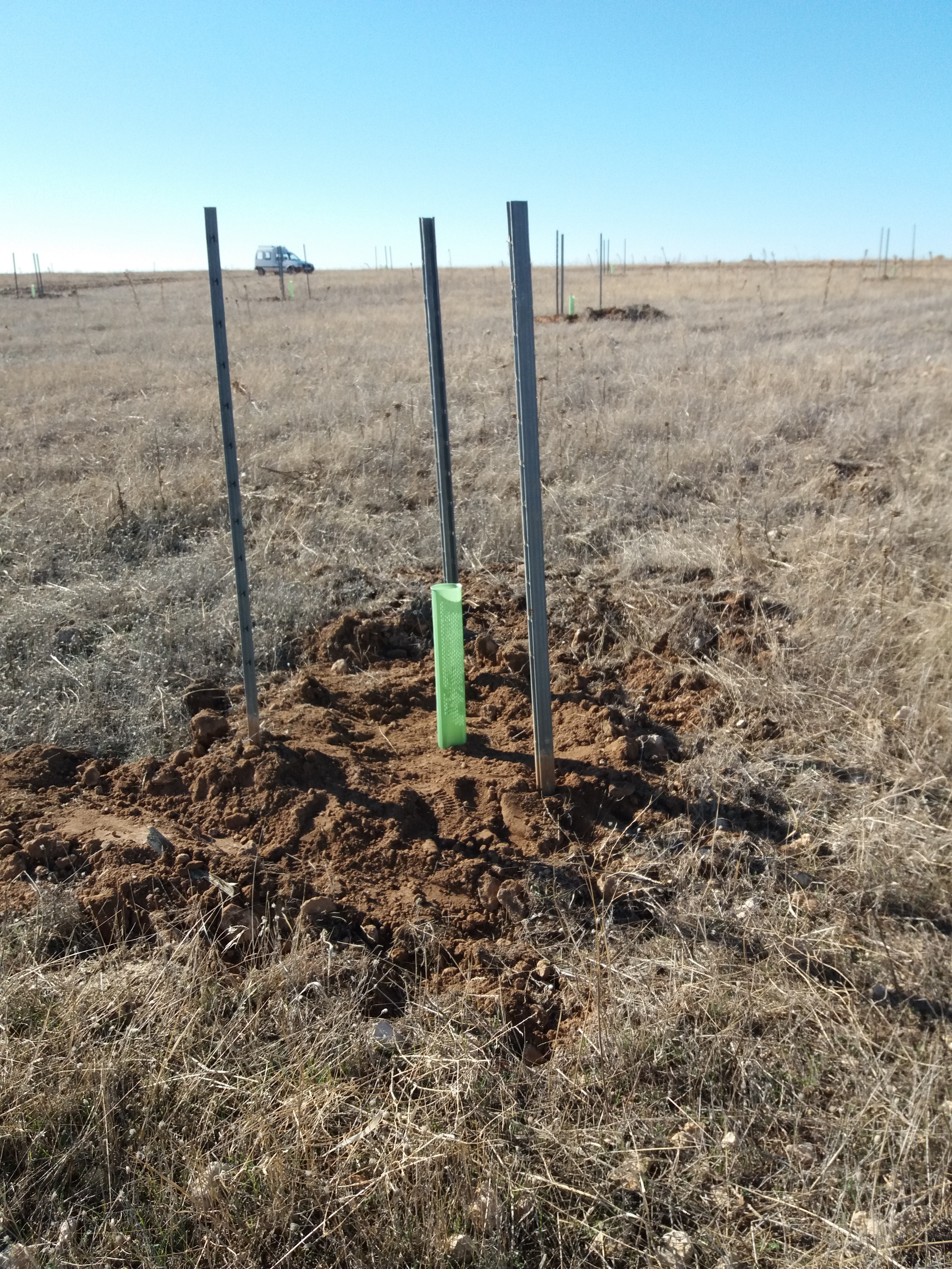
The land preparation involved mechanized digging using a backhoe to create 90x90x90 cm holes, with no other areas of the plot being cleared. Afterward, the removed soil was levelled to avoid leaving mounds that could hinder proper planting or the installation of protective fencing.

Next, enough soil was excavated and loosened to ensure the plant could be easily placed so that the root ball was properly buried, followed by the installation of a biodegradable protective tube 60 cm high.

The size of the hole, somewhat larger than usual, facilitated the placement of three posts to anchor the individual protective mesh around each plant, preventing damage from wildlife or livestock.

Additionally, the increased depth of the work improves water availability for the plant, which is crucial in a region with low rainfall like La Mancha.

Finally, the surrounding soil was compacted to ensure that the removed soil made contact with the root ball, preventing air pockets that could hinder rooting. A tree pit was also constructed to increase the capacity to collect and retain rainwater, which is essential in regions where rainfall is typically scarce, such as La Mancha.

Importance and relevance of the adaptation: 

The most relevant aspect of this project is the conversion of a 104-hectare plot bordering the National Park from intensively irrigated crops to an oak pasture.

The removal of these irrigated crops leads to an improvement in the area's water table levels, which, in turn, serve as one of the most important water sources for the wetland.

Additional Details
Stakeholder engagement: 

The project was executed in accordance with the provisions outlined in the Master Plan for the Use and Management of the Park (PRUG), specifically in article 6.1.3. It was developed under the direction of the Technical Services of the National Park, through an assignment to the public company TRAGSA, which in turn subcontracted a couple of tasks, including mechanized drilling and the installation of posts for protective mesh, to two local companies.

In a preliminary phase, some of the Park's own staff participated, taking responsibility for the collection and selection of seeds, which took place in the area known as Quinto de la Torre, within the National Park itself, covering an area of 125.63 ha with a large number of parent trees. This was done to ensure greater genetic diversity and future adaptability to the terrain.

The selected seeds were transferred to a TRAGSA nursery for germination and care, and the seedlings obtained the MANCHA certificate of origin. They remained there until November 2017, when they were transferred back to the Park for planting.

These preliminary activities incurred no additional cost to the project. All actions were carried out in coordination and under the supervision of the Park's Technical Staff.

Project interest: 

The state of conservation in which the Park is located and the problems that have occurred to date are the result of the interaction of a series of factors, both natural and of anthropic origin, and of the complex relationships and synergies produced in this regard on an enclave that is particularly fragile because it is a wetland immersed in a rainfed environmental territory.

The effect of some processes such as drought episodes, which are becoming increasingly frequent and intense as a result of climate change, has a significant influence on the Park, whose main problems are a consequence of the poor management and planning developed until recently regarding the water resources of the area, hindering the conservation and recovery of habitats and ecosystems, as well as the possibility of sustainable management of its resources.

The excessive drainage of the area, both by direct extraction of surface water and by overexploitation of groundwater, carried out for years intensively, has caused significant damage to the ecosystem, shifting from an agricultural base of traditional rainfed cultivation typical of the region, to a predominant system of irrigated crops with a high demand for water, which has led to the overexploitation of water resources.

All this has caused a drop in the water table and a decrease in the flooded area, as well as pollution problems and eutrophication processes in the lagoons due to the concentration of nutrients from the land adjacent to the riverbeds, contributing to the process of degradation and decrease in the quality of the Tablas ecosystem.

In recent years, the water table in the area has recovered due to the increase in rainfall and an improvement in the management system of the Park and its area of influence, but not due to a potential decrease in consumption, meaning that in new periods of drought, it will once again be below the minimum necessary for its proper functioning.

This means that in order to recover water levels to their optimal level, it would be necessary to eliminate irrigated land to the point that sustainable water management could be carried out.

For all these reasons, this project to convert land from irrigated crops to dryland Mediterranean pastureland, with the restoration of areas by holm oak groves, grasses (Poaceae family), wild legumes (Fabaceae family), and annual pastures, is particularly interesting, also allowing the conservation and recovery of the ecosystem, the restoration of the water balance in the affected area, and the optimal use of its ecosystem resources, improving the socio-economic conditions of the environment with the recovery of natural tourism and grazing of La Mancha sheep.

In this sense, it is necessary to continue carrying out similar actions, eliminating irrigated land to achieve a reduction in water consumption and an adequate reconversion of land, reorienting the structure of the agricultural sector towards a more sustainable management of the system, to achieve the recovery of the hydrological functioning of the Park.

Introducing technical improvements and promoting a socio-economic change in the structure of crops towards a sustainable agricultural system, compatible with the balance of the ecosystem, will improve the quality of the Park and restore its natural operating conditions, with an optimization of its ecosystem services that will undoubtedly have a positive impact on the level of socio-economic development in the area in the long term.

Success and limiting factors: 

The success of afforestation or restoration of native vegetation in the Mediterranean climate hinges on surviving the first summer, and therefore, the planting date is crucial for plants to develop a root system that provides them with sufficient water availability to cope with the high summer evapotranspiration.

Often, due to the deadlines for task execution, climatic conditions, or the characteristics of the plants themselves, this is not always possible, making it necessary to provide external support to improve the water balance of the plants during this critical time.

In this context, there are two approaches:

  • Improve or control water supply (irrigation)
  • Reduce the degree of insolation that plants experience

Implementing an irrigation system considerably increases the execution costs and may be impossible due to the inaccessibility of the land or the lack of a reliable water supply. For this reason, it is often preferable to act on the second approach by installing individual protections, which provide shade, improve water retention, and protect the plants from predators.

One limiting factor for afforestation is the damage caused by wildlife (wild boar) or domestic livestock (sheep, goats), which often browse, trample, dig, or break the seedlings. To minimize this damage, a 1.5-meter-high protective mesh was installed around each plant, with knotted 148/18/15 galvanized mesh, supported by three metal posts.

Budget, funding and additional benefits: 

The budget for this project to convert land from irrigated crops to La Mancha pastures was €83,580.17, being fully financed by the Spanish Office for Climate Change.

Legal aspects: 

The project is affected by the different laws and decrees that affect the structure and figure of the Park itself.

The Las Tablas de Daimiel wetland was declared a National Park in 1973 by Decree 1874/1973, of 28 June, by which Las Tablas de Daimiel was declared the National Park and an Integral Waterbird Reserve area was created within it (BOE 181, of 30 June 1973).

 Likewise, the park was reclassified in 1980 by Law 25/1980, of 3 May, on the Reclassification of the Las Tablas de Daimiel National Park.

In 2007, through the enactment of Law 5/2007, of April 3, referring to the Network of National Parks, where the management powers of these are established.

Later, on January 27, 2014, the limits of the Park were extended by incorporation of adjoining land, according to a resolution to that effect of the Council of Ministers of January 10, 2014.

On December 4 of the same year, the Las Tablas de Daimiel National Park was affected by the new Law 30/2014 on National Parks.

Implementation time: 

The project included a preliminary phase of seed collection and selection carried out in advance, during October 2016, followed by the germination, development, and care of seedlings at a TRAGSA nursery, where they remained until November 2017.

However, the actual planting and reforestation activities were also conducted by TRAGSA personnel, with assistance from the Park Technicians, during November and December 2017, with a total duration of two months.

In summary, the preparation and execution of the project took 14 months in total, although the results will become evident over the coming years.

During December 2018, in collaboration with WWF-Spain, restoration efforts were made on a new area of dehesa on the same affected limestone plot, planting about 50 trees per hectare. This, however, was a complementary action not included in the original project. The work was also carried out by an external contractor, in this case, Retamar - Obras y Servicios y Medio Ambiente SL.

Reference Information
Contact: 
  • Carlos Ruiz de la Hermosa
  • Parque Nacional de Las Tablas de Daimiel
  • Organismo Autónomo Parques Nacionales (OAPN)
  • Correo electrónico: caruiz@oapn.es
  • Teléfono: 926851097
  • Manuel Carrasco Redondo
  • Parque Nacional de Las Tablas de Daimiel
  • Organismo Autónomo Parques Nacionales (OAPN)
  • Correo electrónico: MCarrasco@oapn.es
  • Teléfono: 926851097
Sources: 
  • Alloza J.A.; Vallejo R. 1999. Relación entre las características meteorológicas del año de plantación y los resultados de las repoblaciones. Ecología, 13: 173-187.
  • Birchler T. et al. 1998. La planta ideal: revisión del concepto, parámetros definitorios e implementación práctica. Invest. Agr.: Sist. Recur. For., 7(1- 2).
  • Brais Hermosilla L. 2016. Elaboración de un protocolo para el muestreo en el seguimiento de repoblaciones forestales. Máster Universitario en restauración de ecosistemas. Universidad de Alcalá de Henares.
  • De María A.; Touriño l.; Manzano I.; Domínguez M. 2003. Técnicas de gestión forestal sostenible en la repoblación forestal. SILVANUS ESPAÑA Y SILVANUS GALICIA.
  • Díaz-Cambronero A. 2017. Protocolo para el monitoreo de la forestación realizada en el Parque Nacional de Las Tablas de Daimiel. PIMA. TRAGSA. 41 pp.
  • Domínguez S.; Villar P.; Peñuelas J.L.; Herrero N. 1999. Técnicas de implantación de encinas en terrenos agrícolas. Quercus, 166: 22-25.
  • Gómez V.; Elena R. 1997. Investigación de las marras causadas por factores ecológicos de naturaleza meteorológica. Cuadernos de la S.E.C.F., 4: 13-25.
  • Iglesias A. 2004. Repoblaciones con Quercus ilex L. en zonas degradadas de la provincia de Ávila. Técnicas para mejorar su supervivencia. Tesis doctoral. Universidad Politécnica de Madrid. Escuela Técnica Superior de Ingenieros de Montes.
  • Jódar A.; Albaladejo J.A.; Fernández H. 2016. Análisis de la Evolución y Estado Actual del Parque Nacional Las Tablas de Daimiel (Cuenca Alta del Guadiana, España). CONAMA 2016. 28 Noviembre - 1 Diciembre. Madrid. 81 pp.
  • Morote A.; Orozco E.; Jordán E.; López F.; Herranz J.M.; Martínez J.J.(2001. Evaluación mediante parámetros morfobiométricos de ocho especies autóctonas de matorral empleadas en la forestación de terrenos agrícolas de La Mancha. Escuela Técnica Superior de Ingenieros Agrónomos. Campus universitario. Albacete.
  • Pemán García J. 1997. El control de calidad de las repoblaciones forestales. Rev. Montes, 45: 23-30.
  • Peñuelas J.L.; Ocaña l.; Domínguez S.; Renilla I. 1996. Experiencias sobre control de la competencia herbácea en repoblaciones de terrenos agrícolas abandonados. Resultados de tres años en campo. Rev. Montes, 45: 30-36.
  • Serrada R.; San Miguel A. Selvicultura en dehesas. Departamento de silvopascicultura. Universidad Politécnica de Madrid.
  • Serrada R.; Navarro R.M.; Pemán J. 2005. La calidad de las repoblaciones forestales: una aproximación desde la selvicultura y la ecofisiología. Invest Agrar: Sist Recur For, 14(3): 462-481.
  • Serrada R. 2000. Apuntes de Repoblaciones Forestales. FUCOVASA. Madrid.