Plataforma sobre Adaptación al Cambio Climático en España

You are here

Regional flood management by combining soft and hard engineering solutions, the Norfolk Broadlands

Image from Climate Adapt about this case study
Autor: © BAM Nuttall

Situated in East Anglia, Norfolk Broads (Broadland) is one of the finest areas of wetland in Britain. It includes both open water, the Broads themselves (a network of mostly navigable rivers and lakes), and the low-lying marshland surrounding the tidal reaches of the Yare, Waveney, Bure rivers and their tributaries. These rivers reach the sea at Great Yarmouth. The Broadland Flood Alleviation Project (BFAP) is a long-term 20-years project to provide a range of flood defence improvements, maintenance and emergency response services along the tidal rivers within the Broadland. The project has been mainly prepared based upon strengthening the embankments to resist breaching with sufficient crest raising to protect settlement and contrast expected climate change and sea level rise effects.


Case Study Description
Challenges: 

For many centuries, the rivers of Broadland played an important role, transporting goods and equipment for trade and industry. Today, Broadland is still a busy area, although for different purposes. About fifty per cent of the land is used for traditional farming. The rivers continue to provide major inland navigation, which, together with the Broads, provide access to 125 miles of waterway. Recreation and tourism have become very important, with more than 7 million people visiting the whole Broads area each year (Broads Authority website). In response, the boat hire industry makes an important contribution to the local economy: a total of £584 million was generated within the local economy through visitor and tourism business expenditure.

The area’s attraction is closely linked to its diversity of landscapes and wetland habitats that give it a quality found nowhere else in the country. The area is internationally important for nature conservation: in 1988 the whole of Broadland was designated as having equivalent status to a National Park and, in 2015, the Broads received the official National Park grant. The Broads National Park is looked after by the Broads Authority, the local planning authority.

Being Norfolk a low lying coastal county, climate change and in particular sea level rise are among the major concerns for this tidally dominated site. In 2016, the Broads Authority produced a Climate Change Adaptation Plan, based on an in-depth analysis of the potential climate changes projected to occur in the Broads region. The projected changes were compared to the average observed climate from 1961 to 1990. The data used for the study concentrated on the high emission scenario (RCP8.5). The average monthly maximum temperature is expected to increase by 3.5 °C by 2080. The average monthly precipitation is projected to increase, on average, by 0.62 mm by the 2050s and 1.4 mm by the 2080s. The climate models are reasonably consistent with almost all showing wetter winters, and all but two showing drier summers. The precipitation increases in winter are projected to be on the order of 5-8 mm by the 2050s and 8-13 mm by the 2080s. At the same time, extreme events are expected to increase: both more intense precipitation over shorter periods and longer dry periods.

By the same year (2080s), projections estimate an absolute sea level increase of almost 40 cm compared to the baseline level of 1990 under the medium emissions scenario. Sea level rise will exacerbate storm surge events; water levels within the Broads will likely increase. Higher sea levels can hold back water trying to drain from the rivers, which can directly cause flooding.

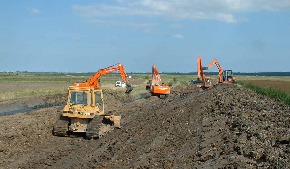
The flood-banks (about 260 km) provide protection to approximately 30,000 ha of land that lies below sea level. All flood banks are subject to deterioration in condition. If not properly maintained and adapted to the new conditions, this phenomenon results in a reduction in the standard of defence provided, making them more susceptible to the impacts of floods.

Objectives: 

The existing embankments have generally been built using the indigenous marshland peats and soft clays. Historic maintenance of defences had not kept pace with the deterioration rate and in the early 1990s they were susceptible to overtopping and breaching by even modest tidal surges. Moreover, the integrity of embankment foundations was put at risk due to erosion of the river banks, caused mainly by boat wash. In 1996, a flood alleviation strategy for Broadland had been prepared based on strengthening the embankments to resist breaching with sufficient crest raising to protect settlement and address projected climate change effects. The first step of the BFAP project is to strengthen existing flood defences and restore them to a height that existed in 1995, taking into consideration sea lever rise and future settlement of the flood banks in future steps. The project is not expected to prevent all future flooding as a consequence of overtopping, but will significantly reduce the risk of breach. This step also included the replacement of existing protection in poor conditions using more environmentally friendly methods, when possible. The second step, planned until 2021, consists of the implementation of a maintenance program for the existing flood banks. This consists, for example, of  grass cutting, erosion control, channel clearance and safety works. It also includes  topping-up flood banks that have settled since being improved earlier in the project.

Moreover, while providing an improved service level in flood defence protection, the project also aims to protect and enhance the Broadlands wetland areas that are rich in biodiversity.

Solutions: 

The low lying land interested by the project is divided into 40 flood protection compartments. These are discrete areas bordered by high ground or flood walls so that if flooding occurs it is likely to be contained within the compartment.

Many flood banks have settled since they were built or last improved and are at risk of being overtopped by even fairly small tidal surges. This is expected to be exacerbated by sea level rise and the potential increase in frequency of storm events. Moreover, in some parts of Broadland the existing defences are threatened due to erosion of the river edge (rond) by wind and waves, boat-wash, normal river flows and the action of the tide. Although some lengths have been protected by steel or timber sheet piles, much of this was installed over the last 40 years and now needs replacing or removing. The existing infrastructure and their degree of deterioration have been considered not enough to counteract the increasing pressure caused by the combined effect of climate change, sea level rise and present pressure due to human activities.

Historically, a large part of the cost of maintaining the flood defences was due to the steel and timber sheet pile erosion protection arrangements installed to prevent the flood banks from being undermined by tidal currents and boat wash. The BFAP sought to replace as much of this hard engineering as possible, with soft solutions such as the creation of natural reedbed habitats along the river edge. This proved to be effective in acting as a natural buffer to the damaging effects of boat wash and strong river flows. It also provided additional benefits appropriate to a national park, as improvements to landscape and ecology.

The project follows a regional concept of flood protection which consists of a combination of hard and soft technical solutions implemented in the first step of BFAP:

  • Flood bank strengthening. This solution is used where the existing reedbed along the river edge is wider than 5m or the erosion protection system or sheet piling is in good condition. This involves the strengthening of the existing flood bank in its present location by placing material on the front and/or back slope of the bank. Raising the crest level may also be necessary and this is usually achieved by placing additional clay at the time of strengthening. The material comes from either widening the existing soke dike or excavating a new one in the grazing marsh. Typically the strengthened banks will have a minimum 2 m crest width and a back slope greater than 1m in 3m. Bank crests are designed to be wide enough to allow maintenance access and further topping up if necessary.
  • Flood bank setback. This option consists of the construction of a new clay embankment, 15m to 30m (setback) behind the existing “soke dike”, the ditch on the marsh side of the river bank, which traps saline water that soaks through from the river, preventing its spread across the reedbed. The actual distance of setback depends on local erosion rates, river depth and the quality of land behind the existing flood bank. Once the new bank has been established, the existing piling or erosion protection is removed, the existing flood bank levelled and the new rivers edge profiled to promote a stable river edge. This is a preferred solution when the bank might become unstable due to failed piling or an eroding reed river edge. Its use is subject to suitable ground conditions and the availability of sufficient material for the new soke dike construction.
  • Flood bank rollback. This option is similar to flood bank setback, however, the distance the flood bank is moved inland is considerably less. This approach reduces the amount of land taken but requires additional material to fill the existing soke dike (for stability reasons). This is a preferred solution when erosion protection is insufficient. It allows for just bank strengthening and where ground conditions, topographical features or structures do not permit full setback. It utilises the total lifespan of any existing piling but relies on adequate remaining life.

The project started in 2001 and will continue until 2021, envisaging an implementation phase to complete the improvement works followed by a maintenance phase. By 2016, the BAFP has reached the end of the first phase completing all the improvement works in the 40 compartments: (i) flood bank strengthening along almost 200 km; (ii) flood bank setback along 50 km; (iii) flood bank re-piling along 7 km; (iv) other erosion protection including asphalt matting and timber poles combined with reed along 20 km; (v) piling removal associated with setback areas along 14.5 km. The BFAP is now progressing with on-going maintenance requirements which consist typically in local crest raising and erosion protection. Erosion protection is carried adopting environmentally-friendly forms of bank protection. Techniques currently used include for example bitumen matting: reeds are planted to grow through the matting, giving a more natural appearance to the riverside. The Broads Authority has produced a guide to protecting banks for further information.

Moreover, since the banks within Broadland are continuously settling, Broadland Environmental Services Ltd (BESL, a private company responsible for certain flood risk management functions ) have an annual yearly crest raising programme which addresses sections of bank which are approaching service level requirements or have been subject to unpredictable settlement. Finally, the project also provides a 24-hour duty roster and emergency response team in the event of major flooding occurrence.

Importance and relevance of the adaptation: 

OTHER_POL_OBJ;

Additional Details
Stakeholder engagement: 

Public participation is an integral part of the BFAP that seeks to involve stakeholders at every opportunity. BFAP has developed a consultation database that contains details of over 1200 stakeholders. These include special-interest groups, businesses, statutory and non-statutory bodies, as well as over 500 landowners. An open approach has been adopted to stakeholder consultation, encouraging the participation of individuals and local interest groups in the development of both strategic and site-specific proposals. Separate participatory consultation exercises are undertaken in locations where the provision of first-time flood protection for riverside properties and boatyards are planned.

The change from vertical piling to more natural river banks has not been welcomed by most boating interests. Piling has provided the facility for casual mooring, added to which there are concerns that piling removal will result in increased rates of sedimentation in the rivers. Action plans for addressing these issues have been developed. For instance, the Local Plan for the Broads for 2015 – 2036 includes indications for mooring provision which take into account different stakeholder interests such as the economy, tourism and biodiversity protection. The provision of a network of moorings throughout the Broads system is essential for local communities, businesses and visitors to the Broads. On the contrary, concentration of visitors where mooring is most plentiful, have an adverse effect on tranquillity and the quiet enjoyment of the Broads. The Authority will therefore protect existing moorings and encourage the provision of new regulated moorings across the system.

Initial public concerns that the project would suffer from the innovative private-public partnership approach due to the need to maximise profit margins have been largely allayed as the partners have shown a willingness to embrace wider benefits. It has, in fact, provided a unique opportunity to integrate flood defence works with other public interest initiatives.

The flood defences have been designed in order to be sustainable and within the strict financial limits of the project. The public participation process has been helping to make sure of this, both for the project overall and each individual scheme within it, by clarifying that each part is:

  • Cost-effective and economically viable;
  • Technically feasible;
  • Socially acceptable, e.g. by identifying the possible impacts on and gains for local communities;
  • Environmentally sound, e.g. by identifying environmental gains where possible and by minimising potential negative impacts where relevant.
Success and limiting factors: 

A major success factor for the project is represented by an effective private-public partnership. In 1992, the British Government launched the Private Finance Initiative, a public-private partnership programme, as a way of providing higher quality and more cost effective public services. Through the Broadland contract the Environment Agency has effectively delegated certain flood risk management functions to a private company, Broadland Environmental Services Ltd. This Private Finance Initiative shell company is used to deliver the contract, comprising stakes of 90% BAM Nuttall Ltd and 10% Halcrow Group Ltd (now CH2M HILL). This Consortium is entrusted with improving and maintaining the Agency’s assets, providing emergency services and acting as a custodian for the environment. A key reason for the success of the Broadland Project has been the equality maintained between the two partner organisations (one public and another one private). The choice of partners and the recognition that each requires the other one’s strengths has been key to building a strong team.

Despite all the positive sides of the implementation of this project, a massive flood protection intervention in a large area such as the one under consideration has also negative impacts. The main limitations (most of them just temporary) identified could be listed as follow:

  • Temporary disturbance to residential property;
  • Possible changes in land use from the construction of the flood defence;
  • Possible impacts on undefended communities by altering the flooding pattern;
  • Temporary visual effects of works during construction;
  • Temporary loss of vegetated areas;
  • Visual impacts of new, large soke dikes;
  • Temporary disturbance of flora and fauna.

Furthermore, although the project encompassed a high level of stakeholder involvement, several landowners opposed to the ‘set-back’ of flood defences on their land. In such cases, a designation of a new alignment of the flood banks allowed to finalise the project implementation phase, avoiding the opposing farmer’s land but at the same time, not guarantying its protection from future flooding events.

In 2017, the Broadland Flood Alleviation Project received the East of England Merit Awards from the Institution of Civil Engineers, recognising excellence in design and construction.

Budget, funding and additional benefits: 

By the end of the project in 2021, the total costs are expected to amount to 136 million UK pounds: 107.7 million can be attributed to new constructions and engineering works, while 31.3 million to ensure maintenance works until 2021. The project is cost limited. This cost ceiling implies that all individual schemes within the project have to be strictly designed to be cost-effective and within the planned programme.

The economic cost of the project is expected to be compensated by benefits represented by significant reduction of the losses for the agricultural sector caused by seawater flood events. One of the main characteristics of this project is the consolidation of the flood banks in order to prevent breaches. When a flood bank breaches, the low lying freshwater marshes are submerged by saline water for a long period, as long as it takes to carry out the repairs, possibly several weeks. This is likely to cause long term and thus expensive damage to the agricultural and nature conservation qualities of the land. When overtopping occurs, saline water flooding still occurs but, because the volume of water is much less and repairs to the flood bank are not usually necessary floodwater can be pumped back into the river within 2-3 days. This is usually quick enough to prevent any significant long term damage to the agricultural land. The difference between the damage costs due to breaching and overtopping is one of the benefits taken into account in designing the project. On the cost side of the calculation, there was only sufficient suitable material available locally to increase the bank heights back to the 1995 levels. To increase the bank heights further and totally prevent overtopping, large volumes of construction materials would need to be transported long distances, the cost of which would have far outweighed the benefits.

The occurrence of three major flood events characterised by high water levels in the period 2006-2013 has allowed to practically show the project’s benefits. In these occasions, the improved flood defences throughout Broadland did not register serious structural damages. In 2013, the area experienced water levels comparable to the great flood event of 1953, which occurred prior to the topping up of the flood banks. Thanks to the interventions implemented within the project, the 2013 event resulted only in two breaches and no property was flooded; in 1953, instead the number of breaches was significantly higher leading to widespread flooding.

Overall, the scheme provides flood protection to 1,700 properties, the A47 highway, the Norwich-Great Yarmouth rail line and 24,000 hectares of agricultural land. Beside the positive economic effects, many secondary social and environmental benefits are also being achieved. These co-benefits include improved pedestrian access though the upgrading of 100km of footpaths, facilities for anglers and mooring provision for the recreational and holiday boating industry. The project has been developed in collaboration with the Norfolk Wildlife Trust and other similar institutions to enhance wetland habitats around the Hickling Broad National Nature Reserve. Consequently, the flood bank modifications has also lead to an improvement in the extent and quality of natural habitats: 55 hectares of freshwater reed-bed were created providing a sustainable, long-term means of erosion protection for the new flood bank. The creation of natural reedbed habitats also contributes to the target required under the Habitats Regulations for losses due to flood risk management schemes on the Suffolk coast.

A formal assessment of the extent to which the project has delivered benefits will likely follow after completion in May 2021.

Legal aspects: 

In 1996, the UK Environment Agency began a process to consider the potential use of the Private Finance Initiative approach for procurement of Flood Risk Management services. As a result, the Broadland Flood Alleviation Project (BFAP) was one of only two selected and designated “significant projects with pathfinder status” by the Treasury. The key feature of the initiative is that, within the Broadland area, the private partner is responsible for providing a specified standard of flood risk management service, including maintenance, improvement works and emergency response. The purpose of this partnership between the public and private sectors is to further drive for cost-effective delivery of public services through operational efficiencies and innovation, and this is embodied in the bespoke contract form.

Implementation time: 

The planned improvement works took 15 years (2001-2016) to be fully implemented. The maintenance phase is still on-going and will be systematically carried out until the end of the BFAP project, in 2021. Beyond 2021, the default for the infrastructure will be to fall under the Environment Agency’s normal programme of monitoring and maintenance.

Reference Information
Contact: 

Paul Mitchelmore
UK Environment Agency
Broadland Flood Alleviation Project
E-mail: paul.mitchelmore@environment-agency.gov.uk 

Kevin Marsh
CH2M HILL
Broadland Flood Alleviation Project
E-mail: kevin.marsh@ch2m.com 

Sources: 

Broadland Flood Alleviation Project and UK Environment Agency