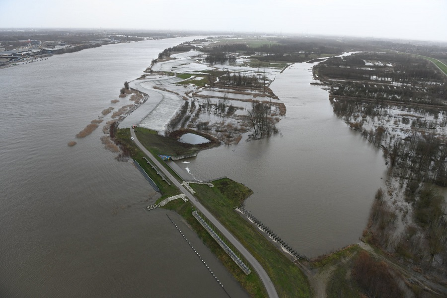
The Kruibeke Bazel Rupelmonde (KBR) Controlled Flood Area was created by lowering the height of the former flood protection dikes along the Scheldt and constructing new dikes further inland at the appropriate flood protection height.
The KBR site provides a major contribution to flood safety along the Scheldt estuary due to its large size (600 hectares), its strategic location and the low level of the land, ensuring a large water storage capacity. The KBR controlled flood area consists of what were originally three separate, contiguous polders (areas of reclaimed land), the Kruibeke, Bazel and Rupelmonde polders. These polders were used predominantly for agricultural and recreational purposes such as fish ponds. While these functions could be conserved to a large degree within a controlled flooding area, it was instead decided to convert the area into a nature area as compensation for areas affected by the expansion of the Antwerp port and work in the Scheldt River. This choice to develop nature within the CFA reflects the integrated approach of the Sigma Plan, which combines flood protection and nature protection.
Already prior to the project, the three polders were designated as Special Protection Zones under the EU Habitats Directive, based in particular on the presence of priority habitats of ‘remaining relict woods on alluvial grounds’. Furthermore, the polders were indicated as protected under the Birds Directive. To create the required compensation for natural areas affected by the port of Antwerp and other infrastructure works, 300 hectares of tidal marshes, 150 hectares of meadow bird area and 91.9 hectares of forest were developed within the Controlled Flood Area.
For the purpose of creating tidal marshes, several weirs have been inserted in the outer dike to allow a controlled tide within the CFA. The system allows water from the Scheldt to flow into the area through high weirs during high tide, and exit the area during low tide through low weirs. The high weirs are important as they allow the effects of high and neap tides to occur within the KBR CFA. Furthermore, the combination of outlet and inlet weirs allows for a regular exchange of organisms and nutrients between the Controlled Flood Area and the Scheldt. One low weir is kept open on a nearly permanent basis to allow a continual exchange of water between the Scheldt and the Kruibeekse Creek. Weirs were designed as fish friendly, to support fish migration. The weirs are also essential for removing excess water from the CFA after storm surge events that overtop the outer dikes. They can also be used prior to an expected storm surge event in order to maximize the water catchment capacity of the CFA.
The CFA came into operation in 2015. It proved its efficacy for the first time during the strong tide event of January 2018, offering a useful buffer area and preventing a dangerous flooding. The polders do not only form a controlled flooding area but they also provide a wide natural area. Through the participation in the LIFE funded SCALLUVIA project (2013-2018), about 90 hectares of alluvial forest and creeks were restored, fish stocks were managed and recreational use of the area was enhanced. In addition, the project has integrated recreational functions throughout the site, including paths for hiking and biking, educational signposts, observation points and recreational fishing opportunities. The polders of Kruibeke, Bazel and Rupelmonde form the largest and most frequented Sigma Plan site in Flanders, which is becoming a popular tourist attraction for leisure activities.
A number of works just outside of the KBR CFA have also been undertaken. They include the creation of a small area of depoldered land along the Scheldt River just in front of the outer dike of the CFA and two water catchment areas on the landward side of the inner dikes. The depoldered area has been fully exposed to the tide as dike protection has been moved further inland, creating a tidal wetland. The two catchment areas were created to store water from the creeks that during normal operation flow through the CFA. During storm surge events, the creeks will not be able to flow into the CFA as the weirs through which the creeks usually flow will be closed, and these catchment areas were built to temporarily store their water. The Northern catchment area has been developed into a recreational area with several fish ponds and a walking path.


